Approximate Location Map
Large Map »
Latitude: 53.8991 / 53°53'56"N
Longitude: -2.7762 / 2°46'34"W
OS Eastings: 349093
OS Northings: 445049
OS Grid: SD490450
Mapcode National: GBR 9R1C.R0
Mapcode Global: WH850.B876
Plus Code: 9C5VV6XF+JG
Entry Name: Church of St Thomas
Listing Date: 17 April 1967
Grade: II
Source: Historic England
Source ID: 1361933
English Heritage Legacy ID: 185502
ID on this website: 101361933
Location: St Thomas's Church, Garstang, Wyre, Lancashire, PR3
County: Lancashire
District: Wyre
Civil Parish: Garstang
Built-Up Area: Garstang
Traditional County: Lancashire
Lieutenancy Area (Ceremonial County): Lancashire
Church of England Parish: Garstang St Thomas
Church of England Diocese: Blackburn
Tagged with: Church building
GARSTANG CHURCH STREET
SD 44 NE
4/108
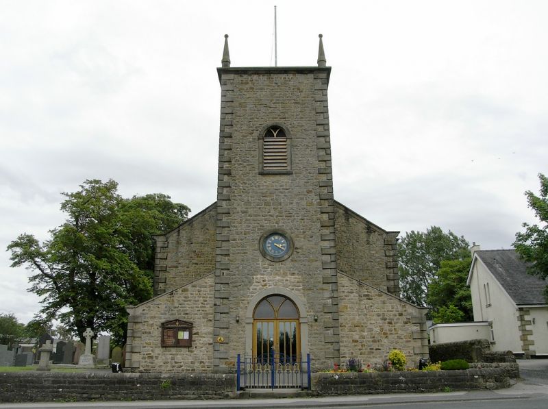
Church of St Thomas
17-4-1967
GV
II
Church, 1770 by Richard Gillow, with chancel added 1876. Sandstone rubble
with slate roofs. Comprises a west tower, nave, and lower chancel with
north transept. Tower and nave have chamfered quoins. Bell openings have
plain stone surrounds with round heads, keystones and impost blocks.
Below, on each of the 3 walls is an oculus with plain stone surround.
North and south doors have similar surrounds. The nave is of 3 bays and
has tall windows similar to the bell openings. They have a central timber
mullion which branches to form Y-tracery, probably a later alteration. The
transept has a tall single light with round head in its north wall. The
east window has 3 similar lights. Interior has west gallery with panelled
front on 2 slim iron columns. The nave has a ribbed ceiling which conceals
the tipper parts of the roof trusses. The chancel arch is round and
plastered. The baluster font has a painted latin inscription with date,
said to be 1770.
Listing NGR: SD4909345049
External links are from the relevant listing authority and, where applicable, Wikidata. Wikidata IDs may be related buildings as well as this specific building. If you want to add or update a link, you will need to do so by editing the Wikidata entry.


Other nearby listed buildings
