Approximate Location Map
Large Map »
Latitude: 53.8494 / 53°50'57"N
Longitude: -2.1043 / 2°6'15"W
OS Eastings: 393234
OS Northings: 439248
OS Grid: SD932392
Mapcode National: GBR FRRX.6T
Mapcode Global: WHB7S.NH4T
Plus Code: 9C5VRVXW+Q7
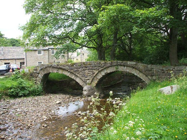
Entry Name: Pack Horse Bridge
Listing Date: 23 April 1952
Grade: II*
Source: Historic England
Source ID: 1243828
English Heritage Legacy ID: 186417
Also known as: Wycoller pack horse bridge
ID on this website: 101243828
Location: Wycoller, Pendle, Lancashire, BB8
County: Lancashire
District: Pendle
Civil Parish: Trawden Forest
Traditional County: Lancashire
Lieutenancy Area (Ceremonial County): Lancashire
Church of England Parish: Trawden St Mary
Church of England Diocese: Blackburn
Tagged with: Packhorse bridge
SD 9339 TRAWDEN WYCOLLER ROAD
17/251 Pack Horse Bridge,
Wycoller
23.4.52
GV II*
Bridge. C17 or perhaps earlier. Of two arches. The arches are segmental, with
roughly dressed voussoirs and a simple band behind them. One leans markedly
outwards. Rubble spandrels and low parapet. Scheduled ancient monument.
Listing NGR: SD9323439248
External links are from the relevant listing authority and, where applicable, Wikidata. Wikidata IDs may be related buildings as well as this specific building. If you want to add or update a link, you will need to do so by editing the Wikidata entry.


Other nearby listed buildings
