Approximate Location Map
Large Map »
Latitude: 52.6699 / 52°40'11"N
Longitude: -0.7263 / 0°43'34"W
OS Eastings: 486229
OS Northings: 308780
OS Grid: SK862087
Mapcode National: GBR CRL.P5L
Mapcode Global: WHFKN.T5B1
Plus Code: 9C4XM79F+XF
Entry Name: 7, Burley Road
Listing Date: 24 November 1971
Grade: II
Source: Historic England
Source ID: 1073299
English Heritage Legacy ID: 186446
ID on this website: 101073299
Location: Oakham, Rutland, LE15
County: Rutland
Civil Parish: Oakham
Built-Up Area: Oakham
Traditional County: Rutland
Lieutenancy Area (Ceremonial County): Rutland
Church of England Parish: Oakham All Saints
Church of England Diocese: Peterborough
Tagged with: Building
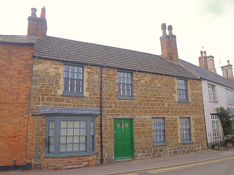
BURLEY ROAD
1.
1469
(East Side)
No 7
SK 8608 6/12
II GV
2.
Mid C18. Dressed stone. Modern tile roof. 2 windows, rusticated
architraves, modern glazing. Band between storeys. 1 ground floor
C19 bay. Plain 4-panel door.
Nos 3 to 17 (odd) form a group.
Listing NGR: SK8622908780
External links are from the relevant listing authority and, where applicable, Wikidata. Wikidata IDs may be related buildings as well as this specific building. If you want to add or update a link, you will need to do so by editing the Wikidata entry.


Other nearby listed buildings
