Approximate Location Map
Large Map »
Latitude: 52.6275 / 52°37'38"N
Longitude: -0.5492 / 0°32'57"W
OS Eastings: 498295
OS Northings: 304289
OS Grid: SK982042
Mapcode National: GBR DTQ.CXW
Mapcode Global: WHGM2.J7P1
Plus Code: 9C4XJFG2+X8
Entry Name: Bridge over the River Chater
Listing Date: 6 June 1961
Grade: II
Source: Historic England
Source ID: 1073859
English Heritage Legacy ID: 187141
ID on this website: 101073859
Location: Ketton, Rutland, PE9
County: Rutland
Civil Parish: Ketton
Built-Up Area: Ketton
Traditional County: Rutland
Lieutenancy Area (Ceremonial County): Rutland
Church of England Parish: Ketton St Mary the Virgin
Church of England Diocese: Peterborough
Tagged with: Bridge
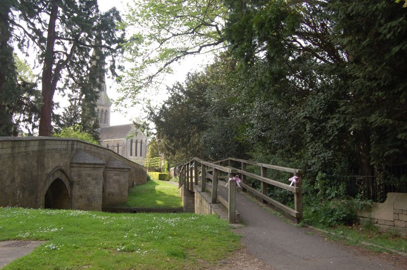
SK 9804-9904 KETTON CHURCH ROAD
15/52
6.6.61 Bridge over the
River Chater
II
Bridge, C17 origin, restored and dated 1849 RH. Ashlar. Three shallow pointed
arches, recessed and with hood moulds, pointed cutwaters with capping between,both
upstream and downstream. Plain coped parapet and wall.
Listing NGR: SK9829504289
External links are from the relevant listing authority and, where applicable, Wikidata. Wikidata IDs may be related buildings as well as this specific building. If you want to add or update a link, you will need to do so by editing the Wikidata entry.


Other nearby listed buildings
