Approximate Location Map
Large Map »
Latitude: 52.6867 / 52°41'12"N
Longitude: -0.6967 / 0°41'48"W
OS Eastings: 488194
OS Northings: 310689
OS Grid: SK881106
Mapcode National: GBR CRF.JPR
Mapcode Global: WHGLM.8QHN
Plus Code: 9C4XM8P3+M8
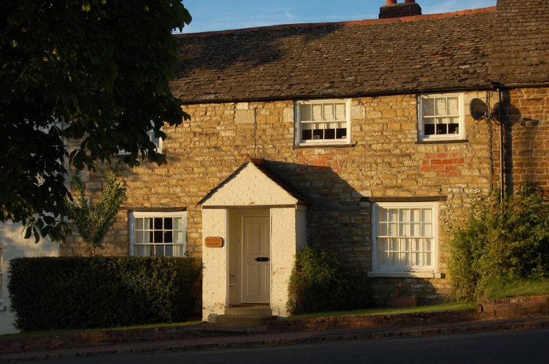
Entry Name: Estate House
Listing Date: 18 September 1984
Grade: II
Source: Historic England
Source ID: 1073758
English Heritage Legacy ID: 187302
ID on this website: 101073758
Location: Burley, Rutland, LE15
County: Rutland
Civil Parish: Burley
Traditional County: Rutland
Lieutenancy Area (Ceremonial County): Rutland
Church of England Parish: Cottesmore, Barrow St Nicholas
Church of England Diocese: Peterborough
Tagged with: House
SK 81 SE BURLEY LANGHAM LANE (north side)
3/19 Estate House
II
House, probably C18. Coursed rubble now whitewashed, with stone tiled roof.
2 storeys. 2 unit plan with central doorway in brick gabled porch.
20-light sash windows to ground floor, 8-light above, with flat timber
lintels. Gable end stacks. To the left a further 2 storey bay added in C19,
with brick cambered heads to sash windows.
Listing NGR: SK8819410689
External links are from the relevant listing authority and, where applicable, Wikidata. Wikidata IDs may be related buildings as well as this specific building. If you want to add or update a link, you will need to do so by editing the Wikidata entry.


Other nearby listed buildings
