Approximate Location Map
Large Map »
Latitude: 52.6008 / 52°36'2"N
Longitude: -1.3839 / 1°23'1"W
OS Eastings: 441827
OS Northings: 300516
OS Grid: SK418005
Mapcode National: GBR 7L5.YS2
Mapcode Global: WHDJD.QW6H
Plus Code: 9C4WJJ28+8F
Entry Name: Hall Farmhouse
Listing Date: 22 October 1952
Last Amended: 13 October 1986
Grade: II*
Source: Historic England
Source ID: 1074243
English Heritage Legacy ID: 188105
ID on this website: 101074243
Location: Sutton Cheney, Hinckley and Bosworth, Leicestershire, CV13
County: Leicestershire
District: Hinckley and Bosworth
Civil Parish: Sutton Cheney
Traditional County: Leicestershire
Lieutenancy Area (Ceremonial County): Leicestershire
Church of England Parish: Market Bosworth St Peter
Church of England Diocese: Leicester
Tagged with: Farmhouse
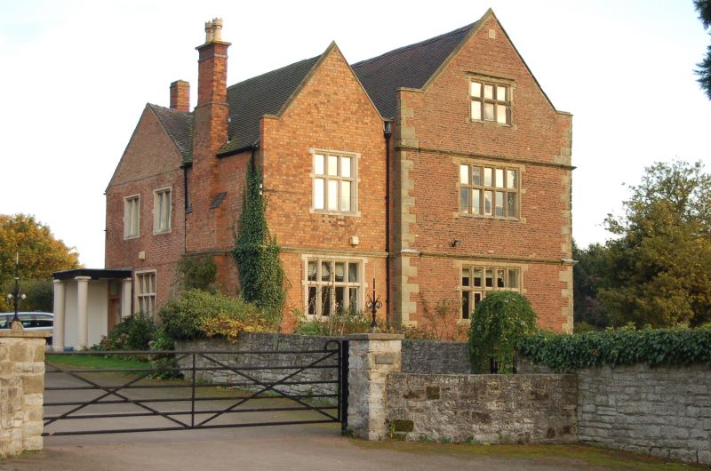
SUTTON CHENEY
SK40 SW MAIN STREET (South East Side)
5/109 Hall Farmhouse
(formerly listed as The Hall)
22.10.52
GV II*
Farmhouse. Early C17 with Victorian Wing. Brick with stone dressings and
plain tiled roofs. Facade to street comprises two gables, that to left a
Victorian addition in the style of the original. The right hand gable has
5-light stone mullioned and transomed windows, with 3-lights to attic. Stone
plinth, angle quoins and continuous moulded string courses which form drip
moulds to ground and first floor windows throughout. All windows have ovolo
moulding. Coped gable with flat flanking parapet. Garden front is a long
range of four bays, with 3-light mullioned and transomed windows throughout,
though two lower windows retaining their architraves, have lost their original
mullions and transoms. Renewed central doorway. Right hand bay is separated
by a projecting stack. Entrance now in Victorian wing to north east, behind
this, the back of the original range is visible, much repaired brickwork and a
date stone re-sited from a garden wall, 1601 with the initials WR. Inside the
original staircase survives, with turned balusters and full height squared
newel.
Listing NGR: SK4182700516
External links are from the relevant listing authority and, where applicable, Wikidata. Wikidata IDs may be related buildings as well as this specific building. If you want to add or update a link, you will need to do so by editing the Wikidata entry.


Other nearby listed buildings
