Approximate Location Map
Large Map »
Latitude: 52.7984 / 52°47'54"N
Longitude: -1.1476 / 1°8'51"W
OS Eastings: 457566
OS Northings: 322656
OS Grid: SK575226
Mapcode National: GBR 8KH.JNN
Mapcode Global: WHDHK.BXRK
Plus Code: 9C4WQVX2+9W
Entry Name: Barn to Holly Tree Farm
Listing Date: 1 June 1966
Grade: II
Source: Historic England
Source ID: 1361143
English Heritage Legacy ID: 189307
ID on this website: 101361143
Location: Hoton, Charnwood, Leicestershire, LE12
County: Leicestershire
District: Charnwood
Civil Parish: Hoton
Traditional County: Leicestershire
Lieutenancy Area (Ceremonial County): Leicestershire
Church of England Parish: Prestwold St Andrew
Church of England Diocese: Leicester
Tagged with: Barn
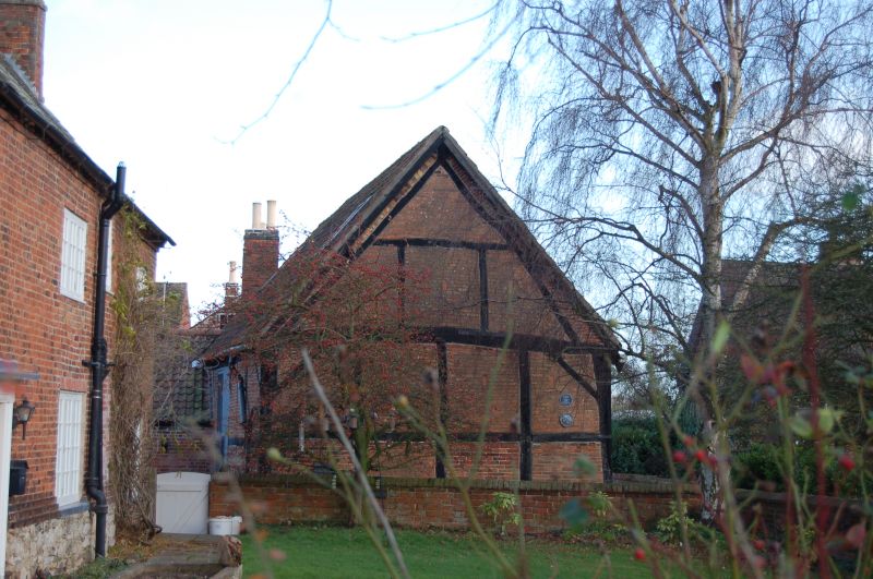
SK 52 SE HOTON WYMESWOLD ROAD
1/49 Barn to Holly Tree Farm
1.6.66
GV II
Barn, early C17. Timber framed with original herringbone brick nogging.
Stone sill, and square panels, with continuous vertical posts, 3 panels high
and 7 long, Double wagon doors to left of centre. Upper cruck visible in
right hand gable. Pantiled roof.
Listing NGR: SK5756622656
External links are from the relevant listing authority and, where applicable, Wikidata. Wikidata IDs may be related buildings as well as this specific building. If you want to add or update a link, you will need to do so by editing the Wikidata entry.


Other nearby listed buildings
