Approximate Location Map
Large Map »
Latitude: 52.7002 / 52°42'0"N
Longitude: -1.0762 / 1°4'34"W
OS Eastings: 462522
OS Northings: 311790
OS Grid: SK625117
Mapcode National: GBR 9N2.QQM
Mapcode Global: WHFK9.FDR9
Plus Code: 9C4WPW2F+3G
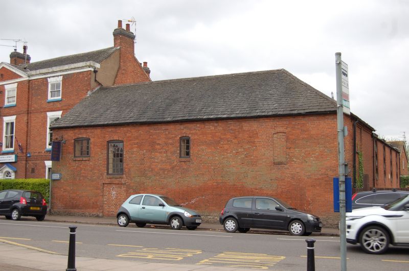
Entry Name: Barn at Number 59
Listing Date: 9 October 1984
Grade: II
Source: Historic England
Source ID: 1361174
English Heritage Legacy ID: 189578
ID on this website: 101361174
Location: Syston, Charnwood, Leicestershire, LE7
County: Leicestershire
District: Charnwood
Civil Parish: Syston
Built-Up Area: Syston
Traditional County: Leicestershire
Lieutenancy Area (Ceremonial County): Leicestershire
Church of England Parish: Syston
Church of England Diocese: Leicester
Tagged with: Barn
SYSTON
SK 6211 HIGH STREET (South Side)
9/112 Barn at No. 59
GV II
Barn, now club premises. Late C18. Brick on cobble stone plinth, with Swithland
slate roof. Blocked ground floor central doorway and 4 segmentally arched
upper openings, one blocked.
Listing NGR: SK6252211790
External links are from the relevant listing authority and, where applicable, Wikidata. Wikidata IDs may be related buildings as well as this specific building. If you want to add or update a link, you will need to do so by editing the Wikidata entry.


Other nearby listed buildings
