Approximate Location Map
Large Map »
Latitude: 52.7795 / 52°46'46"N
Longitude: -0.768 / 0°46'4"W
OS Eastings: 483200
OS Northings: 320922
OS Grid: SK832209
Mapcode National: GBR CQ5.QNL
Mapcode Global: WHFK2.5DKJ
Plus Code: 9C4XQ6HJ+QR
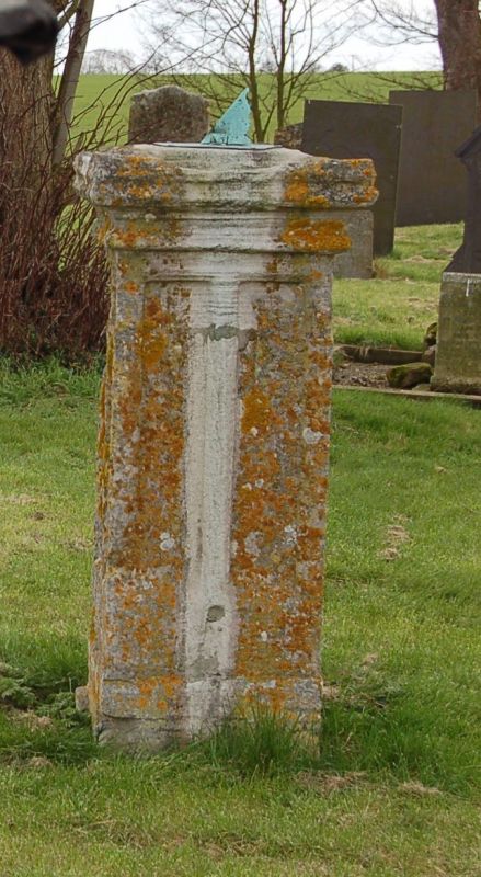
Entry Name: Sundial 50 Metres South East of Church of St Mary
Listing Date: 7 January 1988
Grade: II
Source: Historic England
Source ID: 1061274
English Heritage Legacy ID: 189856
ID on this website: 101061274
Location: St Mary's Church, Garthorpe, Melton, Leicestershire, LE14
County: Leicestershire
District: Melton
Civil Parish: Garthorpe
Traditional County: Leicestershire
Lieutenancy Area (Ceremonial County): Leicestershire
Church of England Parish: Wymondham St Peter
Church of England Diocese: Leicester
Tagged with: Sundial
SK 82 SW GARTHORPE MELTON ROAD
(north side)
1/99 Sundial 50M south
east of Church
of St. Mary
G.V. II
Sundial. Limestone. C15. Remodelled from a pinnacle late C19.
Panelled square shaft with moulded cornice. Round brass dial.
Listing NGR: SK8320020922
External links are from the relevant listing authority and, where applicable, Wikidata. Wikidata IDs may be related buildings as well as this specific building. If you want to add or update a link, you will need to do so by editing the Wikidata entry.


Other nearby listed buildings
