Approximate Location Map
Large Map »
Latitude: 52.8555 / 52°51'19"N
Longitude: -0.798 / 0°47'52"W
OS Eastings: 481030
OS Northings: 329348
OS Grid: SK810293
Mapcode National: GBR CP5.WKW
Mapcode Global: WHFJN.QH57
Plus Code: 9C4XV642+6Q
Entry Name: Wilds Farmhouse
Listing Date: 3 August 1979
Last Amended: 26 February 1992
Grade: II
Source: Historic England
Source ID: 1075055
English Heritage Legacy ID: 190149
ID on this website: 101075055
Location: Branston, Melton, Leicestershire, NG32
County: Leicestershire
District: Melton
Civil Parish: Croxton Kerrial
Traditional County: Leicestershire
Lieutenancy Area (Ceremonial County): Leicestershire
Church of England Parish: Branston-by-Belvoir (High Framland Parishes)
Church of England Diocese: Leicester
Tagged with: Farmhouse
In the entry for
SK 8029 CROXTON KERRIAL MAIN STREET
(east side)
39/347 Branston
3.8.79 Wild's Farmhouse
GV II
The address shall be amended to read
SK 8029 CROXTON KERRIAL MAIN STREET
(east side)
39/347 Branston
3.8.79 Wild's Farmhouse (No 4)
GV II
------------------------------------
SK 8029 CROXTON KERRIAL MAIN STREET
(East side)
Branston
39/347 Wild's Farmhouse
3.8.79
GV II
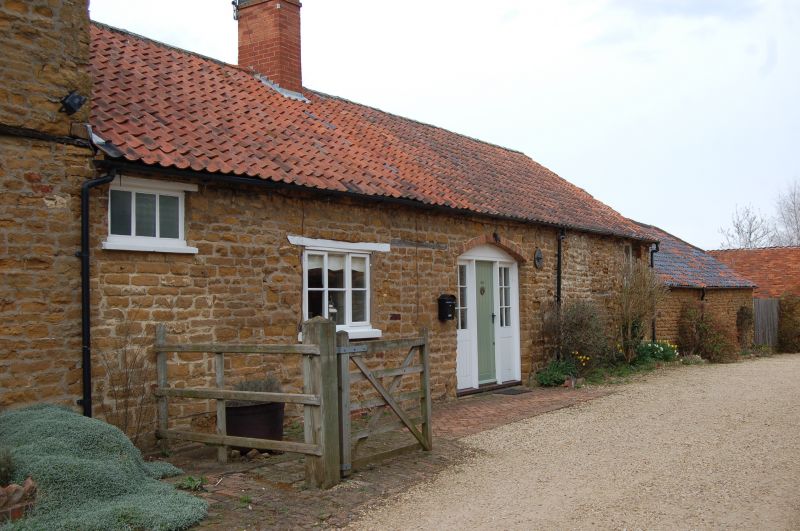
Farmhouse. Mid C18. Coursed ironstone with pantile roof. Modified baffle
entry plan. 2 storeys with attic. West front in 4 bays, the door set to
right of centre behind gabled early C20 timber porch. Fenestration of 3-
light renewed casements with glazing bars, the central lights opening.
Ironstone skewback arches over them, slightly segmental. The window over
door is of 2 lights. To north end of facade are 2 blocked windows of a
former upper half storey. Gabled roof over early C19 brick dentiled eaves
cornice. Brick internal gable end stacks and central ridge stack, all Cl9.
Listing NGR: SK8103029348
External links are from the relevant listing authority and, where applicable, Wikidata. Wikidata IDs may be related buildings as well as this specific building. If you want to add or update a link, you will need to do so by editing the Wikidata entry.


Other nearby listed buildings
