Approximate Location Map
Large Map »
Latitude: 52.7813 / 52°46'52"N
Longitude: -0.9627 / 0°57'45"W
OS Eastings: 470063
OS Northings: 320917
OS Grid: SK700209
Mapcode National: GBR BNL.PFD
Mapcode Global: WHFJZ.5CV4
Plus Code: 9C4XQ2JP+GW
Entry Name: Brook Farmhouse
Listing Date: 22 March 1991
Last Amended: 26 February 1992
Grade: II
Source: Historic England
Source ID: 1360907
English Heritage Legacy ID: 190199
ID on this website: 101360907
Location: Saxelbye, Melton, Leicestershire, LE14
County: Leicestershire
District: Melton
Civil Parish: Grimston
Traditional County: Leicestershire
Lieutenancy Area (Ceremonial County): Leicestershire
Church of England Parish: Saxelbye with Shoby
Church of England Diocese: Leicester
Tagged with: Farmhouse
In the entry for
SK 72 SW GRIMSTON CHURCH LANE
Saxelby
5/480 Brook Farmhouse
GV II
The address shall be amended to read
SK 72 SW GRIMSTON CHURCH LANE
(south east side)
Saxelby
5/480 Brook Farmhouse (No 1)
GV II
-------------------------------------------------------------
GRIMSTON CHURCH LANE
Saxelby
SK 72 SW Brook Farmhouse
5/480
GV II
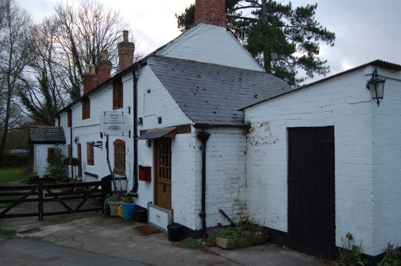
Farmhouse. C17, re-fronted in brick early-mid C19 and extended 1 bay.
Brick, painted, to front, coursed ironstone table to rear wall, Swithland
slate roof, brick end and ridge stacks. 3-unit lobby entry plan originally,
now 4-unit plan. 2-storey, 4-window range. Central, part-glazed door with
segmental-arched head, 3-light casement windows to ground floor except for
2-light casement to far right, all with segmental-arched heads. 3-light
casements to 1st floor with central sliding light and 2-light casement to
1st floor far right, all with wood lintels. Dentilled brick eaves. Right
end bay is an addition. Interior has stop-chamfered spine beams and
inglenook with chamfered bressumer.
Listing NGR: SK7006320917
External links are from the relevant listing authority and, where applicable, Wikidata. Wikidata IDs may be related buildings as well as this specific building. If you want to add or update a link, you will need to do so by editing the Wikidata entry.


Other nearby listed buildings
