Approximate Location Map
Large Map »
Latitude: 52.8132 / 52°48'47"N
Longitude: -0.841 / 0°50'27"W
OS Eastings: 478216
OS Northings: 324596
OS Grid: SK782245
Mapcode National: GBR BNC.Q5P
Mapcode Global: WHFJV.1KT4
Plus Code: 9C4XR575+7J
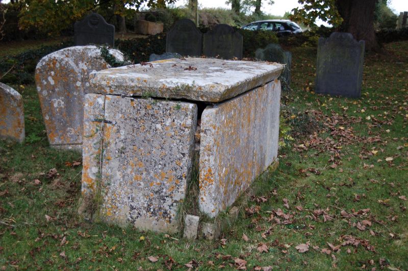
Entry Name: Chest Tomb Approximately 3 Metres South of South Porch of Church of St Mary
Listing Date: 22 March 1991
Grade: II
Source: Historic England
Source ID: 1188627
English Heritage Legacy ID: 190258
ID on this website: 101188627
Location: St Mary's Church, Chadwell, Melton, Leicestershire, LE14
County: Leicestershire
District: Melton
Civil Parish: Scalford
Traditional County: Leicestershire
Lieutenancy Area (Ceremonial County): Leicestershire
Church of England Parish: Scalford with Wycombe and Chadwell
Church of England Diocese: Leicester
Tagged with: Chest tomb
SCALFORD CHADWELL
SK 78 24 Chest tomb approx. 3m S
25/469 of S porch of Church of
St Mary
GV II
Chest tomb. Dated 1779. Limestone.
Very plain with chamfer to lower edge of ledger.
Worn inscription.
Listing NGR: SK7821624596
External links are from the relevant listing authority and, where applicable, Wikidata. Wikidata IDs may be related buildings as well as this specific building. If you want to add or update a link, you will need to do so by editing the Wikidata entry.


Other nearby listed buildings
