Approximate Location Map
Large Map »
Latitude: 52.629 / 52°37'44"N
Longitude: -1.0461 / 1°2'45"W
OS Eastings: 464664
OS Northings: 303898
OS Grid: SK646038
Mapcode National: GBR 9P3.0CW
Mapcode Global: WHFKP.X51W
Plus Code: 9C4WJXH3+HH
Entry Name: The Dower House and Wall
Listing Date: 21 December 1984
Grade: II
Source: Historic England
Source ID: 1061735
English Heritage Legacy ID: 190768
ID on this website: 101061735
Location: Thurnby, Harborough, Leicestershire, LE7
County: Leicestershire
District: Harborough
Civil Parish: Thurnby and Bushby
Built-Up Area: Leicester
Traditional County: Leicestershire
Lieutenancy Area (Ceremonial County): Leicestershire
Church of England Parish: Thurnby St Luke
Church of England Diocese: Leicester
Tagged with: Building
THURNBY
SK 60 SW GRANGE LANE (North Side)
4/110 The Dower House and Wall
GV II
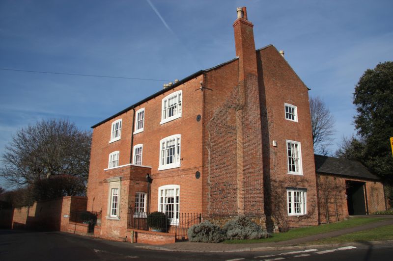
House. C18, extended and altered early C19. Red brick with small section
of rubble stone and Swithland slate roof hipped to left. Brick left ridge
stack and right end projecting and rear stacks. Brick 1st floor band. 3
storeys of 3 sash windows : tripartite 1/1 : 1/1 : 1/1 ; 6/6 and similar
tripartite. Similar on 2nd floor but with central 1/1 sash, and similar on
ground floor. Cambered lintels overall. On ground floor a central parapetted
rectangular porch. Facing lane a 6/6 sash within restored moulded stone frame,
2-light casement on right end of porch, and on left end a restored moulded
stone doorway with 6-panelled door and narrow overlight. On left end mainly
similar sashes. On right end, to right, a bow window with 6/6 sash over and
3/3 sash above. To left the brickwork shows the original C18 gable end with
projecting stack and various blocked windows. Rubble stone plinth to this
section of wall. From the left end of house a brick coped wall c2½m. high
extends along Grange Lane. Included for group value.
Listing NGR: SK6466403898
External links are from the relevant listing authority and, where applicable, Wikidata. Wikidata IDs may be related buildings as well as this specific building. If you want to add or update a link, you will need to do so by editing the Wikidata entry.


Other nearby listed buildings
