Approximate Location Map
Large Map »
Latitude: 52.9402 / 52°56'24"N
Longitude: -0.0635 / 0°3'48"W
OS Eastings: 530230
OS Northings: 339845
OS Grid: TF302398
Mapcode National: GBR JWT.NRH
Mapcode Global: WHHLX.0C19
Plus Code: 9C4XWWRP+3H
Entry Name: 80 Yards of Wall to Frampton House
Listing Date: 26 August 1987
Grade: II
Source: Historic England
Source ID: 1147673
English Heritage Legacy ID: 191990
ID on this website: 101147673
Location: Frampton, Boston, Lincolnshire, PE20
County: Lincolnshire
District: Boston
Civil Parish: Frampton
Traditional County: Lincolnshire
Lieutenancy Area (Ceremonial County): Lincolnshire
Church of England Parish: Frampton St Mary
Church of England Diocese: Lincoln
Tagged with: Building
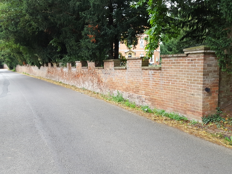
TF 33 NW FRAMPTON WEST END ROAD
(east side)
13/74 80 yds of wall to
Frampton House
G.V. II
Garden wall. Late C18. Brick with ashlar copings. 5'0" high
wall, with castellated top. At the left hand end it terminates
in a splayed re-entrant and at the right hand end in a square
pier.
Listing NGR: TF3023039845
External links are from the relevant listing authority and, where applicable, Wikidata. Wikidata IDs may be related buildings as well as this specific building. If you want to add or update a link, you will need to do so by editing the Wikidata entry.


Other nearby listed buildings
