Approximate Location Map
Large Map »
Latitude: 52.914 / 52°54'50"N
Longitude: -0.6404 / 0°38'25"W
OS Eastings: 491521
OS Northings: 336040
OS Grid: SK915360
Mapcode National: GBR DQ4.6Y4
Mapcode Global: WHGKP.409W
Plus Code: 9C4XW975+HR
Entry Name: 33-37, Castlegate
Listing Date: 20 April 1972
Grade: II
Source: Historic England
Source ID: 1360230
English Heritage Legacy ID: 192932
ID on this website: 101360230
Location: Grantham, South Kesteven, Lincolnshire, NG31
County: Lincolnshire
District: South Kesteven
Electoral Ward/Division: Grantham St Wulfram's
Parish: Non Civil Parish
Built-Up Area: Grantham
Traditional County: Lincolnshire
Lieutenancy Area (Ceremonial County): Lincolnshire
Church of England Parish: Grantham St Wulfram
Church of England Diocese: Lincoln
Tagged with: Building
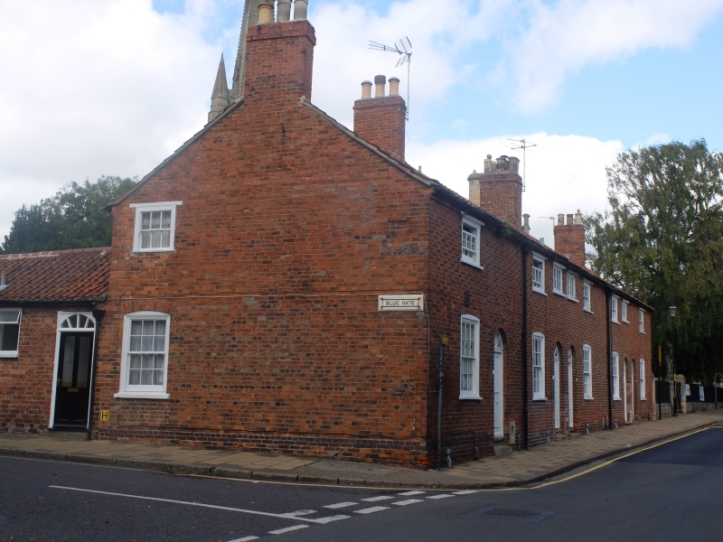
CASTLEGATE
1. (West Side)
1146
Nos. 33 to 37 (consec)
SK 9136 SE 10/211
II
2.
Cottages. Early C19 brick, 2-storey. Pantiles. Small upper window with
narrow flat stone lintel. Ground floor windows have segmental brick arches.
4 fielded door with fanlight and round brick arch. Scrapers.
Listing NGR: SK9152136040
External links are from the relevant listing authority and, where applicable, Wikidata. Wikidata IDs may be related buildings as well as this specific building. If you want to add or update a link, you will need to do so by editing the Wikidata entry.


Other nearby listed buildings
