Approximate Location Map
Large Map »
Latitude: 52.6497 / 52°38'58"N
Longitude: -0.4781 / 0°28'41"W
OS Eastings: 503055
OS Northings: 306858
OS Grid: TF030068
Mapcode National: GBR FVR.ZXX
Mapcode Global: WHGLX.MNJK
Plus Code: 9C4XJGXC+VQ
Entry Name: The George Hotel
Listing Date: 22 May 1954
Grade: II*
Source: Historic England
Source ID: 1169387
English Heritage Legacy ID: 193714
ID on this website: 101169387
Location: Newtown, South Kesteven, Lincolnshire, PE9
County: Lincolnshire
District: South Kesteven
Civil Parish: Stamford
Built-Up Area: Stamford
Traditional County: Northamptonshire
Lieutenancy Area (Ceremonial County): Lincolnshire
Tagged with: Hotel
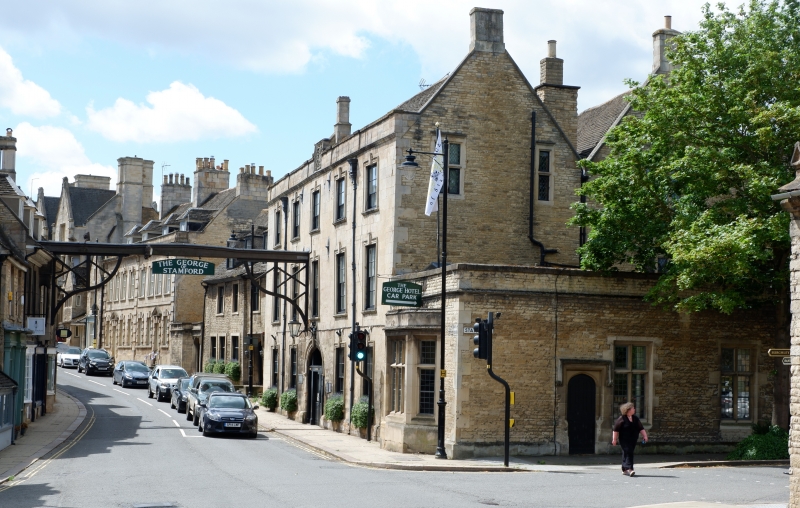
1.
1671
TF 0206 1/236
TF 0306 1/236
22.5.54
ST MARTIN'S
(West Side)
No 70
(The George Hotel)
II*
GV
2.
Front elevation of mid C18. Dated 1728 on rain-water-head). 3 storeys in ashlar,
Moulded stone cornice and panelled parapet, centre containing cartouche with arms
of Earl of Exeter. Stone plinth, probably earlier, 5 windows in moulded stone
surrounds with triple keystones. Central round-headed arch with triple keystone
over modern door C19 wood sign extending across the road, Remains of C17 buildings
on North and to rear. Court to rear is mid C13. 3 storeys, 2 canted bay. The
building stands on the site of 1 originally belonging to the Knights Hospitallers,
and is a large and rambling mixture of many dates. The North elevation contains
remains of 2 gables and several mullioned windows.
Interior:- has been much altered, 1 C18 stone chimney-piece. Remains of a mediaeval
hall, probably C14, including the chamfered fireplace arch and part of the screens
are to be found in the gentlemen's lavatory. Includes rear premises, former stables,
mainly garaging. Early C19. 2 storey in brick.
Nos 39 +o 43 (consec), Garden Wall to No 43, No 44, Wall to No 44, Nos 45 to 70
(consec), Garden Wall to Nos 68 and 69 with Burghley Almshouses form a group.
Listing NGR: TF0305506858
External links are from the relevant listing authority and, where applicable, Wikidata. Wikidata IDs may be related buildings as well as this specific building. If you want to add or update a link, you will need to do so by editing the Wikidata entry.


Other nearby listed buildings
