Approximate Location Map
Large Map »
Latitude: 52.6504 / 52°39'1"N
Longitude: -0.4781 / 0°28'41"W
OS Eastings: 503055
OS Northings: 306934
OS Grid: TF030069
Mapcode National: GBR FVR.ZXN
Mapcode Global: WHGLX.MNK1
Plus Code: 9C4XMG2C+4Q
Entry Name: The Bridge
Listing Date: 26 April 1974
Grade: II
Source: Historic England
Source ID: 1062178
English Heritage Legacy ID: 193716
ID on this website: 101062178
Location: Newtown, South Kesteven, Lincolnshire, PE9
County: Lincolnshire
District: South Kesteven
Civil Parish: Stamford
Built-Up Area: Stamford
Traditional County: Lincolnshire
Lieutenancy Area (Ceremonial County): Lincolnshire
Tagged with: Bridge
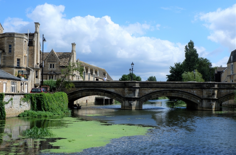
1.
1671 ST MARTIN'S
(West Side)
The Bridge
TF 0306 1/498
II GV
2.
1849. Architect, Edward browning. 3 segmental arches in stone with a moulded
string, Small cutwaters, Plain stone parapet.
Forms a group with The Riverside Club, Nos 4 and 5 St Mary's Hill.
Also forms a group with No 1 St Martin's.
Listing NGR: TF0305506934
External links are from the relevant listing authority and, where applicable, Wikidata. Wikidata IDs may be related buildings as well as this specific building. If you want to add or update a link, you will need to do so by editing the Wikidata entry.


Other nearby listed buildings
