Approximate Location Map
Large Map »
Latitude: 51.4412 / 51°26'28"N
Longitude: 0.1485 / 0°8'54"E
OS Eastings: 549416
OS Northings: 173544
OS Grid: TQ494735
Mapcode National: GBR RZ.S4T
Mapcode Global: VHHNZ.J1CJ
Plus Code: 9F32C4RX+F9
Entry Name: K6 Telephone Kiosk
Listing Date: 13 July 1987
Grade: II
Source: Historic England
Source ID: 1064214
English Heritage Legacy ID: 198742
ID on this website: 101064214
Location: Bexley, London, DA5
County: London
District: Bexley
Electoral Ward/Division: St Mary's
Parish: Non Civil Parish
Built-Up Area: Bexley
Traditional County: Kent
Lieutenancy Area (Ceremonial County): Greater London
Church of England Parish: Bexley St Mary
Church of England Diocese: Rochester
Tagged with: K6 telephone box
JUNCTION OF STATION
5005
APPROACH AND BEXLEY HIGH
STREET
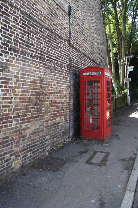
TQ 4973 13/23 K6 Telephone Kiosk
GV II
2.
Telephone kiosk. Type K6. Designed 1935 by Sir Giles Gilbert Scott. Made by
various contractors. Cast iron. Square kiosk with domed roof. Unperforated
crowns to top panels and margin glazing to windows and door.
Listing NGR: TQ4941673544
External links are from the relevant listing authority and, where applicable, Wikidata. Wikidata IDs may be related buildings as well as this specific building. If you want to add or update a link, you will need to do so by editing the Wikidata entry.


Other nearby listed buildings
