Approximate Location Map
Large Map »
Latitude: 51.6532 / 51°39'11"N
Longitude: -0.2027 / 0°12'9"W
OS Eastings: 524428
OS Northings: 196467
OS Grid: TQ244964
Mapcode National: GBR BZ.FL0
Mapcode Global: VHGQ5.FQN0
Plus Code: 9C3XMQ3W+7W
Entry Name: 20, Wood Street
Listing Date: 26 September 1957
Grade: II
Source: Historic England
Source ID: 1286511
English Heritage Legacy ID: 199167
ID on this website: 101286511
Location: Chipping Barnet, Barnet, London, EN5
County: London
District: Barnet
Electoral Ward/Division: High Barnet
Parish: Non Civil Parish
Built-Up Area: Barnet
Traditional County: Hertfordshire
Lieutenancy Area (Ceremonial County): Greater London
Church of England Parish: Chipping Barnet
Church of England Diocese: St.Albans
Tagged with: Building
1.
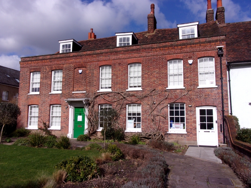
5004 WOOD STREET
(north side)
No 20
TQ 2496 10/19 26.9.57
II
2.
Early/mid C18. Red brick with tiled roof. Two storeys and attic, 6 windows, sashes
with glazing bars in cambered heads. Doorcase with canopy on brackets, 6 panel door.
Three flat topped dormers. All features were restored after severe bomb damage.
Listing NGR: TQ2442596480
External links are from the relevant listing authority and, where applicable, Wikidata. Wikidata IDs may be related buildings as well as this specific building. If you want to add or update a link, you will need to do so by editing the Wikidata entry.


Other nearby listed buildings
