Approximate Location Map
Large Map »
Latitude: 51.4931 / 51°29'35"N
Longitude: 0.072 / 0°4'19"E
OS Eastings: 543935
OS Northings: 179159
OS Grid: TQ439791
Mapcode National: GBR NJ.QSH
Mapcode Global: VHHNK.6QDS
Plus Code: 9F32F3VC+6Q
Entry Name: Royal Arsenal Former New Carriage Store Building 10
Listing Date: 8 June 1973
Last Amended: 9 July 1997
Grade: II
Source: Historic England
Source ID: 1358997
English Heritage Legacy ID: 200492
ID on this website: 101358997
Location: Royal Arsenal West, Greenwich, London, SE18
County: London
District: Greenwich
Electoral Ward/Division: Woolwich Riverside
Parish: Non Civil Parish
Built-Up Area: Greenwich
Traditional County: Kent
Lieutenancy Area (Ceremonial County): Greater London
Church of England Parish: Woolwich St Mary Magdalene with St Michael and All Angels
Church of England Diocese: Southwark
Tagged with: Architectural structure
TQ 4379
786/9/51
08/06/73
PLUMSTEAD ROAD SE18
(North side)
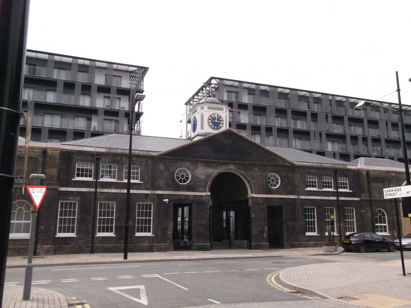
Royal Arsenal Former new Carriage Store (building 10)
GV
II
Carriage works, smitheries and workshops, disused. 1802-05, altered C19, central courtyard totally rebuilt 1937 and 1967. Polychromatic stock brick with pitched slate roof, with galvanised asbestos and outer lead-clad roofs.
PLAN: Single-depth ranges around a large courtyard, with central vehicle entrances to front (north) and rear (south) and single vehicle entrances to middle of both sides.
EXTERIOR: The best-preserved section is the 2-storey north range; symmetrical 3:9:3:9:3:9:3-fenestration under a dentil cornice, the middle 3 pedimented bays set forward with plat band, central round arch flanked by oculi, and a square clock tower behind with ogee roof and iron finial. Flanking sections have gauged brick round-arched ground-floor and segmental-arched first-floor windows, mostly with 6/6-pane sashes; linking gateways have round carriage archways defined by 4 pilasters to coped parapets, the right-hand one with an inserted roller blind, the left-hand one with an inserted tripartite window. The outer former corner engine houses have segmental-arched ground-floor windows and blind panels above, parapets and tall lanterns.
Single-storey side and rear ranges. W side range in similar style as the corner blocks, with central entrance sections with a round-arched gateway flanked by parapets with sunken panels set over segmental-arched windows. The E range was largely rebuilt in the later C19 and mid C20, leaving only fragments of the early C19 building; the rear (south) range was also partly rebuilt but is more complete, retaining one early C19 entrance, and is obscured to its eastern half by later extensions.
INTERIOR: former courtyard area largely altered 1960s. Includes C19 iron roof trusses to single-depth outer ranges; south-central room notable as retaining colonnaded south wall, with bolting holes for line-shafting brackets to cast-iron columns; see RCHME report for further details.
HISTORICAL NOTE: The Royal Carriage Factory produced gun carriages and mounted cannon on them; it was founded in 1728, and the building damaged by fire in 1802. The present building may incorporate some of the earlier structure, and surrounded a large smithery within the courtyard. The front (north) range is the most complete and significant remaining element of the 1802-5 factory building, and the eastern and southern (rear) ranges have been partly rebuilt. Although the east and south ranges clearly have less intrinsic interest than the more complete north and west ranges, they are included in the listing because they comprise part of the courtyard plan, which defines the extent of one of the largest planned groups of engineering workshops of its period in the world, also illustrative of the scale of cannon making in the Napoleonic Wars: only fragments have survived from the internal courtyard, which originally comprised open avenues planned around three parallel smitheries, each flanked by wheelers' shops.
(RCHME report, 1994)
Listing NGR: TQ4393579159
External links are from the relevant listing authority and, where applicable, Wikidata. Wikidata IDs may be related buildings as well as this specific building. If you want to add or update a link, you will need to do so by editing the Wikidata entry.


Other nearby listed buildings
