Approximate Location Map
Large Map »
Latitude: 51.4972 / 51°29'50"N
Longitude: -0.258 / 0°15'28"W
OS Eastings: 521016
OS Northings: 179028
OS Grid: TQ210790
Mapcode National: GBR 8S.CMQ
Mapcode Global: VHGQX.GMYK
Plus Code: 9C3XFPWR+VQ
Entry Name: Pillar Box in Bedford Road at Junction with the Orchard
Listing Date: 19 January 1981
Grade: II
Source: Historic England
Source ID: 1358736
English Heritage Legacy ID: 200885
ID on this website: 101358736
Location: Bedford Park, Ealing, London, W4
County: London
District: Ealing
Electoral Ward/Division: Southfield
Parish: Non Civil Parish
Built-Up Area: Ealing
Traditional County: Middlesex
Lieutenancy Area (Ceremonial County): Greater London
Church of England Parish: St Michael and All Angels Bedford Park
Church of England Diocese: London
Tagged with: Pillar box
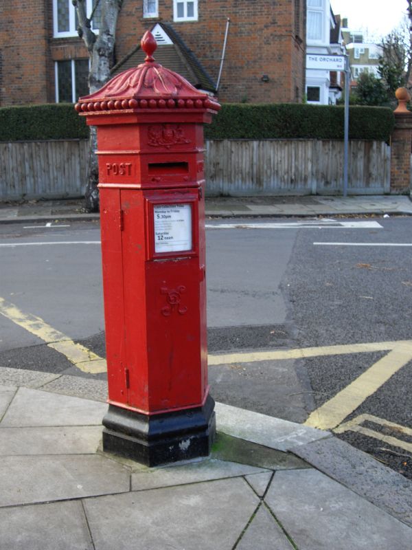
BEDFORD ROAD
1.
5010
(south side)
W4
Pillar-box in
Bedford Road at
junction with
The Orchard
TQ 2179 7/28
II
2.
1872 type. Cast iron. Penfold hexagonal box.
Listing NGR: TQ2101679028
External links are from the relevant listing authority and, where applicable, Wikidata. Wikidata IDs may be related buildings as well as this specific building. If you want to add or update a link, you will need to do so by editing the Wikidata entry.


Other nearby listed buildings
