Approximate Location Map
Large Map »
Latitude: 51.4991 / 51°29'56"N
Longitude: -0.2549 / 0°15'17"W
OS Eastings: 521233
OS Northings: 179240
OS Grid: TQ212792
Mapcode National: GBR 9M.6FK
Mapcode Global: VHGQX.JLM4
Plus Code: 9C3XFPXW+J3
Entry Name: 10, Blenheim Road
Listing Date: 2 February 1970
Grade: II
Source: Historic England
Source ID: 1079448
English Heritage Legacy ID: 200905
ID on this website: 101079448
Location: Bedford Park, Ealing, London, W4
County: London
District: Ealing
Electoral Ward/Division: Southfield
Parish: Non Civil Parish
Built-Up Area: Ealing
Traditional County: Middlesex
Lieutenancy Area (Ceremonial County): Greater London
Church of England Parish: St Michael and All Angels Bedford Park
Church of England Diocese: London
Tagged with: Building
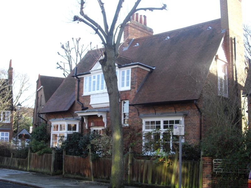
BLENHEIM ROAD
1.
5010
(south side)
No 10
TQ 2179 7/12 2.2.70
II GV
2.
Circa 1876. By W Wilson. Red brick with tiled roof. Two storeys, with 2
single storeyed bay windows. Pedimented dormer. Central doorway with flat
hood. End gable tile hung.
Listing NGR: TQ2123379240
External links are from the relevant listing authority and, where applicable, Wikidata. Wikidata IDs may be related buildings as well as this specific building. If you want to add or update a link, you will need to do so by editing the Wikidata entry.


Other nearby listed buildings
