Approximate Location Map
Large Map »
Latitude: 51.5142 / 51°30'51"N
Longitude: -0.3455 / 0°20'43"W
OS Eastings: 514905
OS Northings: 180771
OS Grid: TQ149807
Mapcode National: GBR 67.7L5
Mapcode Global: VHFTD.Y6QK
Plus Code: 9C3XGM73+MR
Entry Name: The Hermitage
Listing Date: 3 December 1953
Grade: II
Source: Historic England
Source ID: 1294382
English Heritage Legacy ID: 200913
Also known as: The Hermitage, Hanwell
ID on this website: 101294382
Location: Hanwell, Ealing, London, W7
County: London
District: Ealing
Electoral Ward/Division: Hobbayne
Parish: Non Civil Parish
Built-Up Area: Ealing
Traditional County: Middlesex
Lieutenancy Area (Ceremonial County): Greater London
Church of England Parish: St Mary Hanwell
Church of England Diocese: London
Tagged with: Cottage orné Cottage
CHURCH ROAD
1.
5010
Hanwell
W7
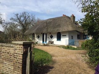
The Hermitage
TQ 18 SW 1/26 3.12.53.
II
2.
Early C19. "Cottage orne". Stucco. Thatch. Quatrefoil and point arched
casement windows with ornamental glazing bars. Central French window with
ogee arch. Octagonal hall and saloon.
Listing NGR: TQ1490580771
External links are from the relevant listing authority and, where applicable, Wikidata. Wikidata IDs may be related buildings as well as this specific building. If you want to add or update a link, you will need to do so by editing the Wikidata entry.


Other nearby listed buildings
