Approximate Location Map
Large Map »
Latitude: 51.4965 / 51°29'47"N
Longitude: -0.2574 / 0°15'26"W
OS Eastings: 521063
OS Northings: 178946
OS Grid: TQ210789
Mapcode National: GBR 8S.KR8
Mapcode Global: VHGQX.HN84
Plus Code: 9C3XFPWV+J2
Entry Name: 8 and 10, Newton Grove
Listing Date: 2 February 1970
Grade: II
Source: Historic England
Source ID: 1079395
English Heritage Legacy ID: 200977
ID on this website: 101079395
Location: Bedford Park, Ealing, London, W4
County: London
District: Ealing
Electoral Ward/Division: Southfield
Parish: Non Civil Parish
Built-Up Area: Ealing
Traditional County: Middlesex
Lieutenancy Area (Ceremonial County): Greater London
Church of England Parish: St Michael and All Angels Bedford Park
Church of England Diocese: London
Tagged with: Building
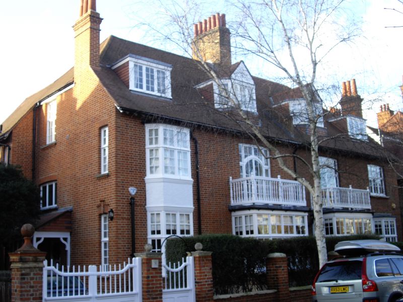
NEWTON GROVE
1.
5010
(west side)
Nos 8 and 10
TQ 2178 9/4 2.2.70
II GV
2.
Circa 1882. Probably by E J May. Red brick with tiled roofs. Three storey
pair with entrance porches at sides. Bays of one and two storeys.
Brick piers and dwarf walls to front garden.
Listing NGR: TQ2106378946
External links are from the relevant listing authority and, where applicable, Wikidata. Wikidata IDs may be related buildings as well as this specific building. If you want to add or update a link, you will need to do so by editing the Wikidata entry.


Other nearby listed buildings
