Approximate Location Map
Large Map »
Latitude: 51.4966 / 51°29'47"N
Longitude: -0.2568 / 0°15'24"W
OS Eastings: 521104
OS Northings: 178956
OS Grid: TQ211789
Mapcode National: GBR 8S.KXQ
Mapcode Global: VHGQX.HNL2
Plus Code: 9C3XFPWV+J7
Entry Name: 3, Newton Grove
Listing Date: 2 February 1970
Grade: II
Source: Historic England
Source ID: 1189370
English Heritage Legacy ID: 200980
ID on this website: 101189370
Location: Bedford Park, Ealing, London, W4
County: London
District: Ealing
Electoral Ward/Division: Southfield
Parish: Non Civil Parish
Built-Up Area: Ealing
Traditional County: Middlesex
Lieutenancy Area (Ceremonial County): Greater London
Church of England Parish: St Michael and All Angels Bedford Park
Church of England Diocese: London
Tagged with: Building
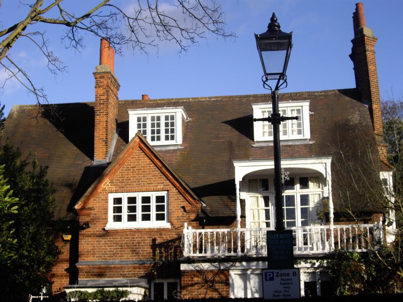
NEWTON GROVE
1.
5010
(east side)
No 3
TQ 2178 9/6 2.2.70
II
GV
2.
Circa 1880. By R Norman Shaw. A variant on the second detached design.
Red brick with red tile roof. Two storeys and attics. Bay-window to right.
Tall moulded brick stacks at either end of the roof.
Listing NGR: TQ2110478956
External links are from the relevant listing authority and, where applicable, Wikidata. Wikidata IDs may be related buildings as well as this specific building. If you want to add or update a link, you will need to do so by editing the Wikidata entry.


Other nearby listed buildings
