Approximate Location Map
Large Map »
Latitude: 51.5658 / 51°33'57"N
Longitude: 0.2166 / 0°12'59"E
OS Eastings: 553728
OS Northings: 187547
OS Grid: TQ537875
Mapcode National: GBR TF.57T
Mapcode Global: VHHN7.PXV0
Plus Code: 9F32H688+8J
Entry Name: Orangery at Langtons
Listing Date: 19 January 1978
Grade: II
Source: Historic England
Source ID: 1079918
English Heritage Legacy ID: 201545
ID on this website: 101079918
Location: Hornchurch, Havering, London, RM11
County: London
District: Havering
Electoral Ward/Division: St Andrew's
Parish: Non Civil Parish
Built-Up Area: Havering
Traditional County: Essex
Lieutenancy Area (Ceremonial County): Greater London
Church of England Parish: Hornchurch St Andrew
Church of England Diocese: Chelmsford
Tagged with: Orangery
1.
5017
TQ 58 NW
10/9A
19.1.78
BILLET LANE
Hornchurch
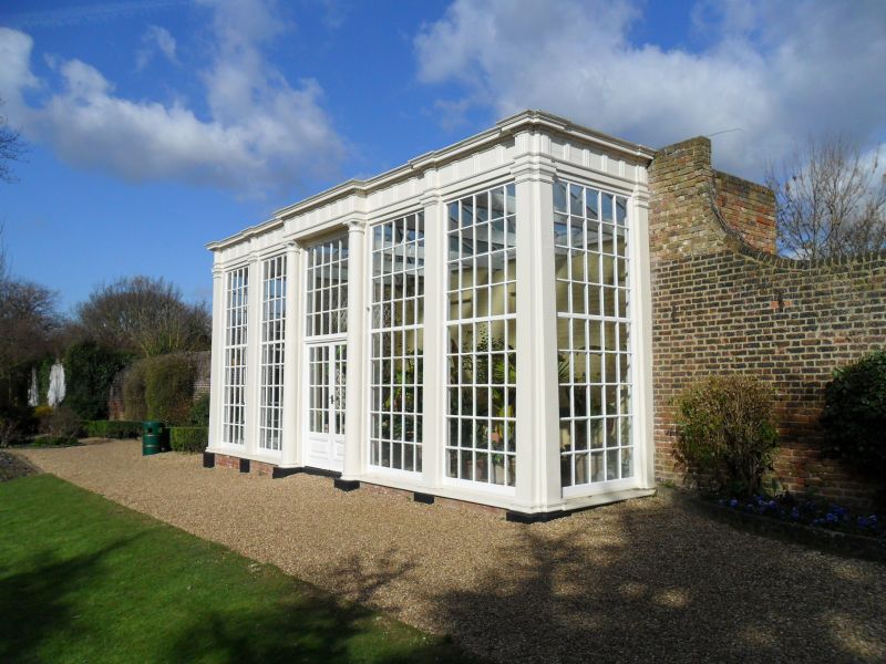
Orangery at Langtons
II
GV
2.
Probably late C18. Front of wood, divided into 5 bays by pilasters, 3/4
Doric columns to centre. Doric entablature across whole front with triglyphs
and dentils. Windows with glazing bars. Rear wall brick.
Listing NGR: TQ5372887547
External links are from the relevant listing authority and, where applicable, Wikidata. Wikidata IDs may be related buildings as well as this specific building. If you want to add or update a link, you will need to do so by editing the Wikidata entry.


Other nearby listed buildings
