Approximate Location Map
Large Map »
Latitude: 51.5904 / 51°35'25"N
Longitude: 0.1971 / 0°11'49"E
OS Eastings: 552294
OS Northings: 190240
OS Grid: TQ522902
Mapcode National: GBR TC.DCC
Mapcode Global: VHHN7.C9J3
Plus Code: 9F32H5RW+5R
Entry Name: Sections of Boundary Wall, Railings, Gates and Gate Piers to Former Gidea Hall
Listing Date: 31 July 1973
Grade: II
Source: Historic England
Source ID: 1079895
English Heritage Legacy ID: 201585
ID on this website: 101079895
Location: Gidea Park, Havering, London, RM2
County: London
District: Havering
Electoral Ward/Division: Pettits
Parish: Non Civil Parish
Built-Up Area: Havering
Traditional County: Essex
Lieutenancy Area (Ceremonial County): Greater London
Church of England Parish: Gidea Park St Michael and All Saints
Church of England Diocese: Chelmsford
Tagged with: Building
TQ 5290 HEATH DRIVE
Gidea Park
940/3/8
Sections of boundary wall,
31.06.73 Railings, gates and gate
Piers to former Gidea Hall
II
Includes: Sections of boundary wall, railings, gates and gate piers to former Gidea Hall, MEAD CLOSE Gidea Park.
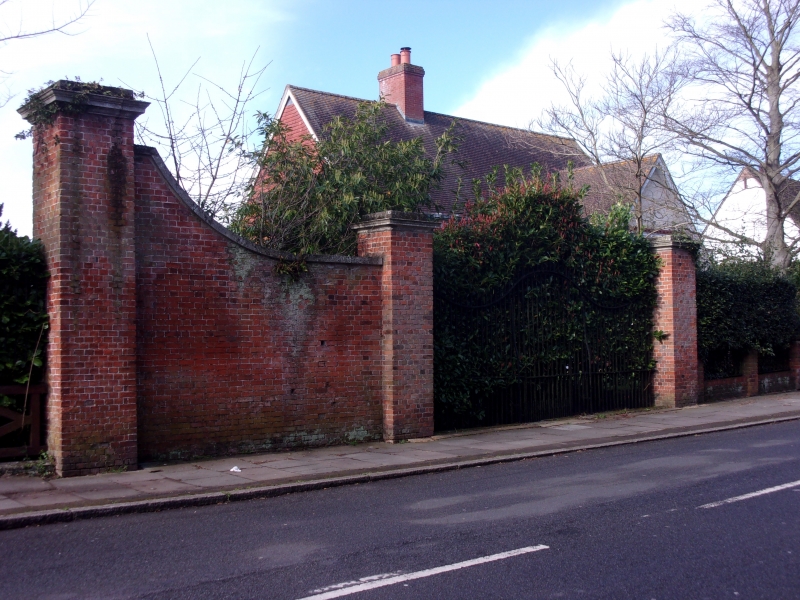
Boundary walls, railings, gates and gate piers. The surviving sections of walling were formerly around the grounds of Gidea Hall (demolished 1929). Dated stone inscribed "WC AXII 1750" on the garden side. Considerably altered section to south on Heath Drive has one pair of square gate piers with a further taller pier to south. Red brick. Stone entablature caps to piers, and coping to wall which is swept up to south. Short sections of iron railings with gate. Spiked uprights arranged with modulating top. After a short break the brick wall continues to north with a longer section. Flat buttresses. Cement coping. Garden entrance with iron gate under segmental brick arch rises in middle. Second gated entrance to north. Large square pier with stone entablature at corner where wall is returned away from the street. The brick wall continues to south-west at an increased height, with one interruption at Mead Close.
Listing NGR: TQ5229490240
External links are from the relevant listing authority and, where applicable, Wikidata. Wikidata IDs may be related buildings as well as this specific building. If you want to add or update a link, you will need to do so by editing the Wikidata entry.


Other nearby listed buildings
