Approximate Location Map
Large Map »
Latitude: 51.6176 / 51°37'3"N
Longitude: 0.1831 / 0°10'59"E
OS Eastings: 551235
OS Northings: 193234
OS Grid: TQ512932
Mapcode National: GBR SG.NV2
Mapcode Global: VHHN1.4L4S
Plus Code: 9F32J59M+26
Entry Name: Rose Cottage
Listing Date: 14 September 1979
Grade: II
Source: Historic England
Source ID: 1079908
English Heritage Legacy ID: 201622
ID on this website: 101079908
Location: Havering-atte-Bower, Havering, London, RM4
County: London
District: Havering
Electoral Ward/Division: Havering Park
Parish: Non Civil Parish
Built-Up Area: Havering
Traditional County: Essex
Lieutenancy Area (Ceremonial County): Greater London
Church of England Parish: Collier Row St James and St John, Havering-atte-Bower
Church of England Diocese: Chelmsford
Tagged with: Cottage
NORTH ROAD
1.
5107
Havering-Atte-Bower
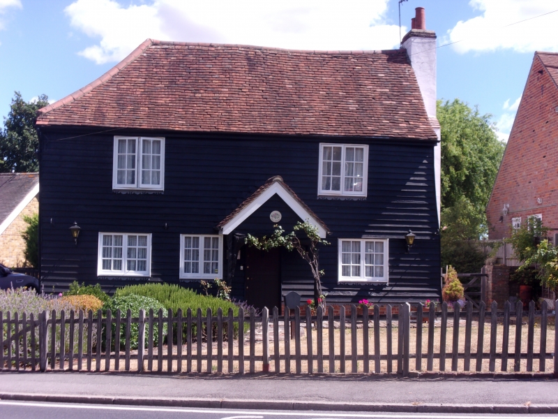
Rose Cottage
TQ 5095/5195 1/14
II
2.
C18, perhaps before 1750. Small timber-framed, weatherboarded cottage with
tiled roof hipped at one end. Two storeys, 2 casement windows over projecting
C19 shop-front. External brick stack. Later rear wing.
Listing NGR: TQ5123593234
External links are from the relevant listing authority and, where applicable, Wikidata. Wikidata IDs may be related buildings as well as this specific building. If you want to add or update a link, you will need to do so by editing the Wikidata entry.


Other nearby listed buildings
