Approximate Location Map
Large Map »
Latitude: 51.5722 / 51°34'19"N
Longitude: -0.3382 / 0°20'17"W
OS Eastings: 515265
OS Northings: 187234
OS Grid: TQ152872
Mapcode National: GBR 63.PD8
Mapcode Global: VHGQH.3R23
Plus Code: 9C3XHMC6+VP
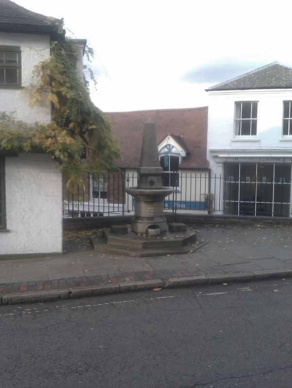
Entry Name: Drinking Fountain Adjacent to Number 36
Listing Date: 25 May 1983
Grade: II
Source: Historic England
Source ID: 1193585
English Heritage Legacy ID: 202083
ID on this website: 101193585
Location: Harrow, London, HA1
County: London
District: Harrow
Electoral Ward/Division: Harrow on the Hill
Parish: Non Civil Parish
Built-Up Area: Harrow
Traditional County: Middlesex
Lieutenancy Area (Ceremonial County): Greater London
Church of England Parish: St Mary Harrow-on-the-Hill
Church of England Diocese: London
Tagged with: Drinking fountain
HIGH STREET
1.
5016
(west side)
Harrow-on-the-Hill
Drinking fountain adjacent
to No 36
TQ 1587 SW 16/26
II
2.
1880. Granite. Octagonal base in stone. Circular shaft and projecting bowl with
leafed spouts. Stumpy obelisk capping.
Listing NGR: TQ1526587234
External links are from the relevant listing authority and, where applicable, Wikidata. Wikidata IDs may be related buildings as well as this specific building. If you want to add or update a link, you will need to do so by editing the Wikidata entry.


Other nearby listed buildings
