Approximate Location Map
Large Map »
Latitude: 51.4084 / 51°24'30"N
Longitude: -0.3061 / 0°18'21"W
OS Eastings: 517912
OS Northings: 169065
OS Grid: TQ179690
Mapcode National: GBR 79.5HJ
Mapcode Global: VHGR8.NV1Q
Plus Code: 9C3XCM5V+8H
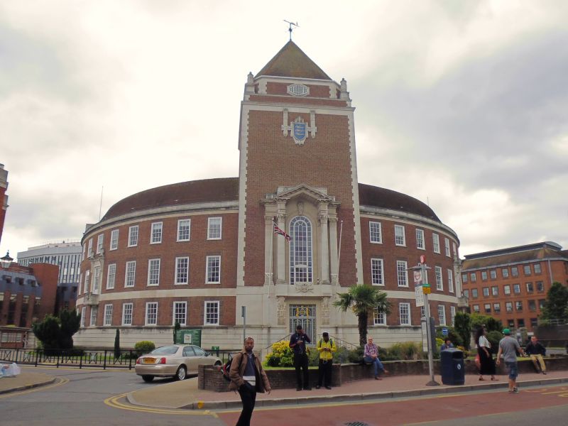
Entry Name: The Guildhall
Listing Date: 6 October 1983
Grade: II
Source: Historic England
Source ID: 1080065
English Heritage Legacy ID: 203120
ID on this website: 101080065
Location: Kingston upon Thames, London, KT1
County: London
District: Kingston upon Thames
Electoral Ward/Division: Grove
Parish: Non Civil Parish
Built-Up Area: Kingston upon Thames
Traditional County: Surrey
Lieutenancy Area (Ceremonial County): Greater London
Church of England Parish: All Saints, Kingston-on-Thames
Church of England Diocese: Southwark
Tagged with: City hall Seat of local government
1934-5. Maurice Webb. Neo Georgian red brick building with Portland stone dressings and tiled roof. Semi-circular plan. Three storeys with square headed twelve paned windows. Horizontally rusticated stone base. Stone band above first floor. To centre of semi-circular elevation a massive square tower with a low octagonal spire and fluted corner pinnacles. Central entrance in base, of tower. Two storey, round headed window above set in open pedimented stone niche with simplified Corinthian columns rising from corbelled balcony. Pictorial references to the Thames displayed upon keystone inside niche, corbels, capitals and on the iron gates. Crest of Kingston set further up the tower. Marble lined circular entrance hall. Central staircase with original opaque glass semi-spherical lamps. Original wall and hanging lights in south west, council chamber, also of opaque glass with bronze trimming.
Listing NGR: TQ1788669005
This list entry was subject to a Minor Amendment on 16/02/2016
Kingston upon Thames, historically in Surrey, was an important market town, port and river crossing from the early medieval period, while there is evidence of Saxon settlement and of activity dating from the prehistoric period and of Roman occupation. It is close to the important historic royal estates at Hampton Court, Bushy Park, Richmond and Richmond Park. The old core of the town, around All Saints Church (C14 and C15, on an earlier site) and Market Place, with its recognisably medieval street pattern, is ‘the best preserved of its type in outer London’ (Pevsner and Cherry, London: South, 1983 p. 307). Kingston thrived first as an agricultural and market town and on its historic industries of malting, brewing and tanning, salmon fishing and timber exporting, before expanding rapidly as a suburb after the arrival of the railway in the 1860s. In the later C19 it become a centre of local government, and in the early C20 became an important shopping and commercial centre. Its rich diversity of buildings and structures from all periods reflect the multi-facetted development of the town.
External links are from the relevant listing authority and, where applicable, Wikidata. Wikidata IDs may be related buildings as well as this specific building. If you want to add or update a link, you will need to do so by editing the Wikidata entry.


Other nearby listed buildings
