Approximate Location Map
Large Map »
Latitude: 51.4109 / 51°24'39"N
Longitude: -0.2989 / 0°17'56"W
OS Eastings: 518402
OS Northings: 169360
OS Grid: TQ184693
Mapcode National: GBR 83.TK9
Mapcode Global: VHGR8.RSVR
Plus Code: 9C3XCP62+9C
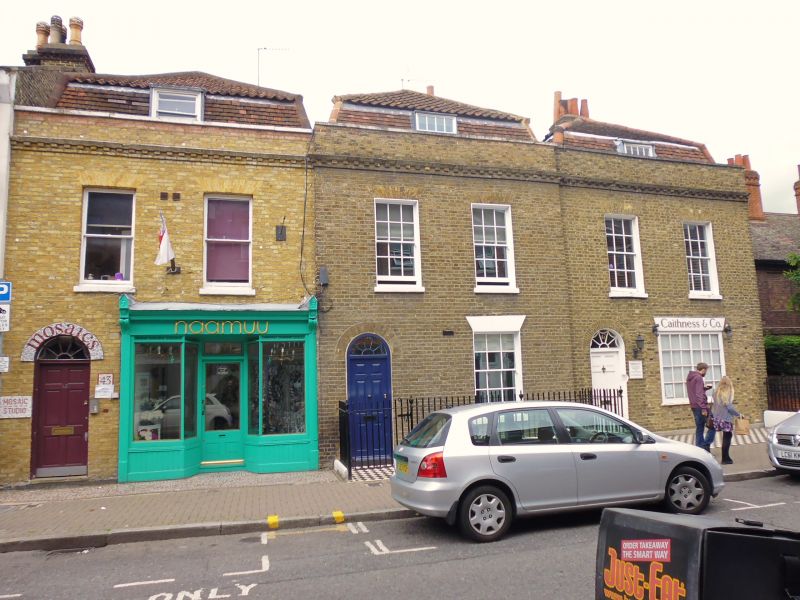
Entry Name: 43-47, Old London Road
Listing Date: 6 October 1983
Grade: II
Source: Historic England
Source ID: 1080073
English Heritage Legacy ID: 203137
ID on this website: 101080073
Location: Kingston upon Thames, London, KT2
County: London
District: Kingston upon Thames
Electoral Ward/Division: Grove
Parish: Non Civil Parish
Built-Up Area: Kingston upon Thames
Traditional County: Surrey
Lieutenancy Area (Ceremonial County): Greater London
Church of England Parish: Norbiton St Peter
Church of England Diocese: Southwark
Tagged with: Building
(Formerly listed under LONDON ROAD)
3 late C18 houses, each of 2 storeys with a mansard garret and 2 bays wide. No 45 set slightly forward. Nos 43 and 47 have modern shops on the ground floor. Yellow brick (No 43 painted), with flat, gauged brick window arches. Round-arched doorways, Nos 43 and 47's with fanlights. Parapet above a blocked cornice with stone cymatium. Pan- and plain-tiled roofs. Listed primarily for group value.
Listing NGR: TQ1840269360
This list entry was subject to a Minor Amendment on 09/03/2016
Kingston upon Thames, historically in Surrey, was an important market town, port and river crossing from the early medieval period, while there is evidence of Saxon settlement and of activity dating from the prehistoric period and of Roman occupation. It is close to the important historic royal estates at Hampton Court, Bushy Park, Richmond and Richmond Park. The old core of the town, around All Saints Church (C14 and C15, on an earlier site) and Market Place, with its recognisably medieval street pattern, is ‘the best preserved of its type in outer London’ (Pevsner and Cherry, London: South, 1983 p. 307). Kingston thrived first as an agricultural and market town and on its historic industries of malting, brewing and tanning, salmon fishing and timber exporting, before expanding rapidly as a suburb after the arrival of the railway in the 1860s. In the later C19 it become a centre of local government, and in the early C20 became an important shopping and commercial centre. Its rich diversity of buildings and structures from all periods reflect the multi-facetted development of the town.
External links are from the relevant listing authority and, where applicable, Wikidata. Wikidata IDs may be related buildings as well as this specific building. If you want to add or update a link, you will need to do so by editing the Wikidata entry.


Other nearby listed buildings
