Approximate Location Map
Large Map »
Latitude: 51.4092 / 51°24'33"N
Longitude: -0.3064 / 0°18'23"W
OS Eastings: 517883
OS Northings: 169162
OS Grid: TQ178691
Mapcode National: GBR 78.ZB4
Mapcode Global: VHGR8.MVV1
Plus Code: 9C3XCM5V+MC
Entry Name: Druid's Head Public House
Listing Date: 6 October 1983
Grade: II*
Source: Historic England
Source ID: 1184751
English Heritage Legacy ID: 203156
Also known as: Druid's Head, Kingston upon Thames
ID on this website: 101184751
Location: Kingston upon Thames, London, KT1
County: London
District: Kingston upon Thames
Electoral Ward/Division: Grove
Parish: Non Civil Parish
Built-Up Area: Kingston upon Thames
Traditional County: Surrey
Lieutenancy Area (Ceremonial County): Greater London
Church of England Parish: All Saints, Kingston-on-Thames
Church of England Diocese: Southwark
Tagged with: Pub
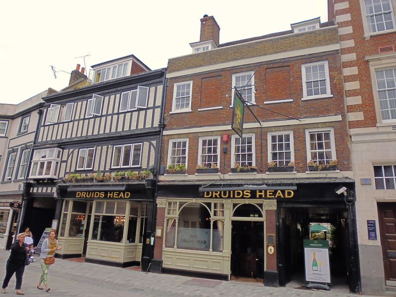
C17 and C18. 3 storey, 5 bay early to mid C18 front. The ground floor has a late C19 pilastered pub front and, on the right, a carriageway through to the rear. The upper floors are faced with red brick with blue brick headers, stucco bands at each floor and yellow flat gauged brick arches to the first floor windows. Flush-framed barred sash window. Tiled roof behind a parapet. 2 dormers. The back wall is later C17. Red brick ith a band at 2nd floor level and 2 mullioned and transomed timber windows on the 2nd floor. Good surviving circa early C18 features to interior, including turned baluster open well staircase, heavily moulded plaster ceilings over staircase, and to first floor front room timber panelling, (some moulded) cornices, fireplaces and doors, etc.
Listing NGR: TQ1788069160
This list entry was subject to a Minor Amendment on 16/02/2016
Kingston upon Thames, historically in Surrey, was an important market town, port and river crossing from the early medieval period, while there is evidence of Saxon settlement and of activity dating from the prehistoric period and of Roman occupation. It is close to the important historic royal estates at Hampton Court, Bushy Park, Richmond and Richmond Park. The old core of the town, around All Saints Church (C14 and C15, on an earlier site) and Market Place, with its recognisably medieval street pattern, is ‘the best preserved of its type in outer London’ (Pevsner and Cherry, London: South, 1983 p. 307). Kingston thrived first as an agricultural and market town and on its historic industries of malting, brewing and tanning, salmon fishing and timber exporting, before expanding rapidly as a suburb after the arrival of the railway in the 1860s. In the later C19 it become a centre of local government, and in the early C20 became an important shopping and commercial centre. Its rich diversity of buildings and structures from all periods reflect the multi-facetted development of the town.
External links are from the relevant listing authority and, where applicable, Wikidata. Wikidata IDs may be related buildings as well as this specific building. If you want to add or update a link, you will need to do so by editing the Wikidata entry.


Other nearby listed buildings
