Approximate Location Map
Large Map »
Latitude: 51.4065 / 51°24'23"N
Longitude: -0.3055 / 0°18'19"W
OS Eastings: 517954
OS Northings: 168859
OS Grid: TQ179688
Mapcode National: GBR 79.5NL
Mapcode Global: VHGR8.NXB4
Plus Code: 9C3XCM4V+JQ
Entry Name: 5 and 6, Oaklea Passage
Listing Date: 6 October 1983
Grade: II
Source: Historic England
Source ID: 1080081
English Heritage Legacy ID: 203164
ID on this website: 101080081
Location: Kingston upon Thames, London, KT1
County: London
District: Kingston upon Thames
Electoral Ward/Division: Grove
Parish: Non Civil Parish
Built-Up Area: Kingston upon Thames
Traditional County: Surrey
Lieutenancy Area (Ceremonial County): Greater London
Church of England Parish: All Saints, Kingston-on-Thames
Church of England Diocese: Southwark
Tagged with: Building
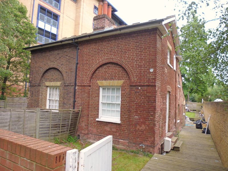
Late C18/early C19 pair of single bay cottages. Brown brick with yellow brick gauged flat arches (No 5 painted). Slate roofs (modern tiles to No 5) with overhanging eaves. End elevations with deep verge overhanging to gable. 1½ storeys. The 2 bay elevation to the public way has sash windows (modern lights to No 5) at ground floor only, set in a pair of tall, shallow recesses with semi-circular 2 ring arches springing from an impost band. Above this, the upper storey is windowless. Each end elevation single bay with entrance door set in the recess and a window over to light the upper storey. Framed by brick pilaster strips carrying the pedimental gable.
Listing NGR: TQ1795468858
This list entry was subject to a Minor Amendment on 09/03/2016
Kingston upon Thames, historically in Surrey, was an important market town, port and river crossing from the early medieval period, while there is evidence of Saxon settlement and of activity dating from the prehistoric period and of Roman occupation. It is close to the important historic royal estates at Hampton Court, Bushy Park, Richmond and Richmond Park. The old core of the town, around All Saints Church (C14 and C15, on an earlier site) and Market Place, with its recognisably medieval street pattern, is ‘the best preserved of its type in outer London’ (Pevsner and Cherry, London: South, 1983 p. 307). Kingston thrived first as an agricultural and market town and on its historic industries of malting, brewing and tanning, salmon fishing and timber exporting, before expanding rapidly as a suburb after the arrival of the railway in the 1860s. In the later C19 it become a centre of local government, and in the early C20 became an important shopping and commercial centre. Its rich diversity of buildings and structures from all periods reflect the multi-facetted development of the town.
External links are from the relevant listing authority and, where applicable, Wikidata. Wikidata IDs may be related buildings as well as this specific building. If you want to add or update a link, you will need to do so by editing the Wikidata entry.


Other nearby listed buildings
