Approximate Location Map
Large Map »
Latitude: 51.4108 / 51°24'38"N
Longitude: -0.3066 / 0°18'23"W
OS Eastings: 517869
OS Northings: 169331
OS Grid: TQ178693
Mapcode National: GBR 78.Z89
Mapcode Global: VHGR8.MSSW
Plus Code: 9C3XCM6V+89
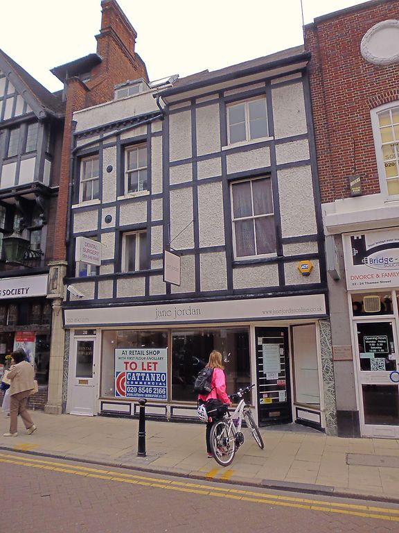
Entry Name: 26 and 28, Thames Street
Listing Date: 6 October 1983
Grade: II
Source: Historic England
Source ID: 1358454
English Heritage Legacy ID: 203191
ID on this website: 101358454
Location: Kingston upon Thames, London, KT1
County: London
District: Kingston upon Thames
Electoral Ward/Division: Grove
Parish: Non Civil Parish
Built-Up Area: Kingston upon Thames
Traditional County: Surrey
Lieutenancy Area (Ceremonial County): Greater London
Church of England Parish: All Saints, Kingston-on-Thames
Church of England Diocese: Southwark
Tagged with: Building
Late C17 or early C18 altered, now one shop, formerly separate premises. Modern shop on ground floor. Upper floors refaced with early C20 half-timbering (of little interest). Separate roofs to each building: No 26 has a slated front slope on eaves; No 28 has a steeply pitched tiled roof behind a parapet. At the back to the churchyard, the buildings remain separate. No 26 has an early C18, or late C17, plum brick rear wall one bay wide, with dentil eaves cornice and steeply pitched, tiled roof with some peg tiles. No 28 projects beyond No 26. Mid to late 17th century. Brown brick with red dressings. 2 bays, the left hand narrower, containing door to ground floor. Three storeys. Square headed sash windows (renewed). Elaborate shouldered relieving arches over windows and door to ground and first floor with strong keystones, in cut brick. Hipped, tiled roof joining front slope at right angles. Moulded eaves cornice.
Listing NGR: TQ1786969331
This list entry was subject to a Minor Amendment on 09/03/2016
Kingston upon Thames, historically in Surrey, was an important market town, port and river crossing from the early medieval period, while there is evidence of Saxon settlement and of activity dating from the prehistoric period and of Roman occupation. It is close to the important historic royal estates at Hampton Court, Bushy Park, Richmond and Richmond Park. The old core of the town, around All Saints Church (C14 and C15, on an earlier site) and Market Place, with its recognisably medieval street pattern, is ‘the best preserved of its type in outer London’ (Pevsner and Cherry, London: South, 1983 p. 307). Kingston thrived first as an agricultural and market town and on its historic industries of malting, brewing and tanning, salmon fishing and timber exporting, before expanding rapidly as a suburb after the arrival of the railway in the 1860s. In the later C19 it become a centre of local government, and in the early C20 became an important shopping and commercial centre. Its rich diversity of buildings and structures from all periods reflect the multi-facetted development of the town.
External links are from the relevant listing authority and, where applicable, Wikidata. Wikidata IDs may be related buildings as well as this specific building. If you want to add or update a link, you will need to do so by editing the Wikidata entry.


Other nearby listed buildings
