Approximate Location Map
Large Map »
Latitude: 51.4119 / 51°24'42"N
Longitude: -0.2993 / 0°17'57"W
OS Eastings: 518373
OS Northings: 169465
OS Grid: TQ183694
Mapcode National: GBR 83.TF2
Mapcode Global: VHGR8.RSM1
Plus Code: 9C3XCP62+P7
Entry Name: Bentalls Depository
Listing Date: 8 September 1989
Grade: II
Source: Historic England
Source ID: 1253306
English Heritage Legacy ID: 203207
ID on this website: 101253306
Location: Kingston upon Thames, London, KT1
County: London
District: Kingston upon Thames
Electoral Ward/Division: Grove
Parish: Non Civil Parish
Built-Up Area: Kingston upon Thames
Traditional County: Surrey
Lieutenancy Area (Ceremonial County): Greater London
Church of England Parish: Norbiton St Peter
Church of England Diocese: Southwark
Tagged with: Architectural structure
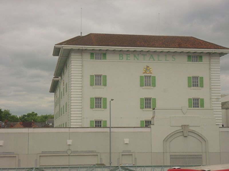
Includes Bentall's Depository. Clarence Street. Depository and store. 1935-6 by Maurice Webb. Rendered steel frame; hipped Spanish tile roof. Grand Spanish/Italianate style. 3 storeys and attic over open ground floor; 7-window range with hipped roof to central tower. Square-headed entry to centre; square-headed metal casements with central opening lights flanked by green shutters. Wide banded quoin strips; cill band to attic storey is broken by tall central window flanked by shutters set in keyed semicircular moulded arch; tiled lettering beneath eaves of central tower; wide bracketed eaves. Rear elevation to Clarence Street, also with central tower and 3-bay side elevations are in similar style. Interior not inspected.
Recommended as an industrial building of unusually good quality, with hacienda-style detailing applied to correct classical proportions of an American scale.
Listing NGR: TQ1837369465
This list entry was subject to a Minor Amendment on 09/03/2016.
Kingston upon Thames, historically in Surrey, was an important market town, port and river crossing from the early medieval period, while there is evidence of Saxon settlement and of activity dating from the prehistoric period and of Roman occupation. It is close to the important historic royal estates at Hampton Court, Bushy Park, Richmond and Richmond Park. The old core of the town, around All Saints Church (C14 and C15, on an earlier site) and Market Place, with its recognisably medieval street pattern, is ‘the best preserved of its type in outer London’ (Pevsner and Cherry, London: South, 1983 p. 307). Kingston thrived first as an agricultural and market town and on its historic industries of malting, brewing and tanning, salmon fishing and timber exporting, before expanding rapidly as a suburb after the arrival of the railway in the 1860s. In the later C19 it become a centre of local government, and in the early C20 became an important shopping and commercial centre. Its rich diversity of buildings and structures from all periods reflect the multi-facetted development of the town.
External links are from the relevant listing authority and, where applicable, Wikidata. Wikidata IDs may be related buildings as well as this specific building. If you want to add or update a link, you will need to do so by editing the Wikidata entry.


Other nearby listed buildings
