Approximate Location Map
Large Map »
Latitude: 51.4954 / 51°29'43"N
Longitude: -0.1206 / 0°7'14"W
OS Eastings: 530561
OS Northings: 179057
OS Grid: TQ305790
Mapcode National: GBR KL.23
Mapcode Global: VHGQZ.VPL0
Plus Code: 9C3XFVWH+5Q
Entry Name: Wall to West of the Great Hall at Lambeth
Listing Date: 27 March 1981
Grade: II
Source: Historic England
Source ID: 1116383
English Heritage Legacy ID: 204402
ID on this website: 101116383
Location: Lambeth, London, SE1
County: London
District: Lambeth
Electoral Ward/Division: Bishop's
Parish: Non Civil Parish
Built-Up Area: Lambeth
Traditional County: Surrey
Lieutenancy Area (Ceremonial County): Greater London
Church of England Parish: North Lambeth
Church of England Diocese: Southwark
Tagged with: Wall
LAMBETH PALACE ROAD SE1
1. (east side)
5023
Wall to west of the
Great Hall at
Lambeth Palace
TQ 3079 2/587
II
2.
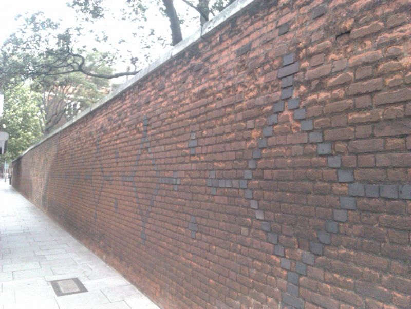
Probably C19 tall red brick wall with blue diaper. Plain stone coping. Door
at north end with stone hoodmould.
Listing NGR: TQ3056279061
External links are from the relevant listing authority and, where applicable, Wikidata. Wikidata IDs may be related buildings as well as this specific building. If you want to add or update a link, you will need to do so by editing the Wikidata entry.


Other nearby listed buildings
