Approximate Location Map
Large Map »
Latitude: 51.4662 / 51°27'58"N
Longitude: -0.1438 / 0°8'37"W
OS Eastings: 529035
OS Northings: 175775
OS Grid: TQ290757
Mapcode National: GBR CX.WK
Mapcode Global: VHGR5.GDBT
Plus Code: 9C3XFV84+FF
Entry Name: 26, Lillieshall Road SW4
Listing Date: 17 July 1978
Grade: II
Source: Historic England
Source ID: 1065044
English Heritage Legacy ID: 204461
ID on this website: 101065044
Location: Clapham, Lambeth, London, SW4
County: London
District: Lambeth
Electoral Ward/Division: Clapham Town
Parish: Non Civil Parish
Built-Up Area: Lambeth
Traditional County: Surrey
Lieutenancy Area (Ceremonial County): Greater London
Church of England Parish: Clapham St Paul
Church of England Diocese: Southwark
Tagged with: Building
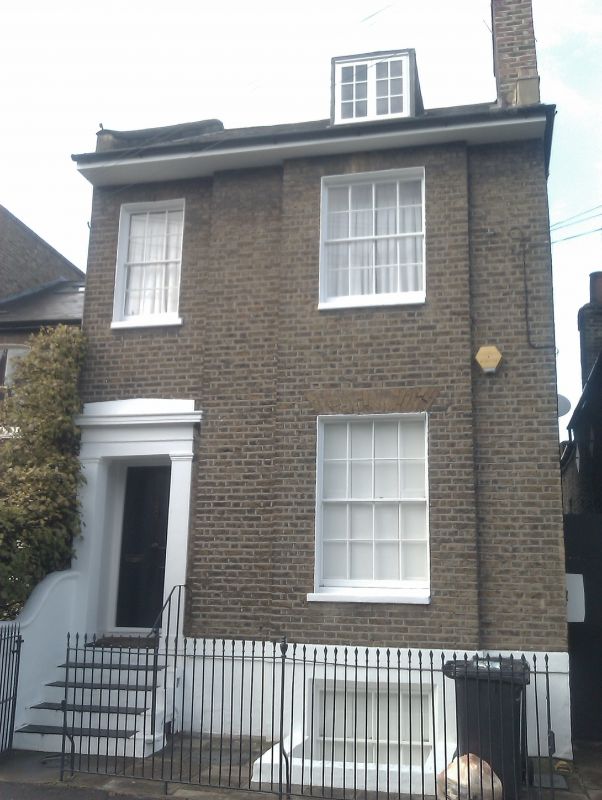
LILLIESHALL ROAD SW4
1. (north side)
5023
No 26
TQ 2975 16/1106 17.7.78
II GV
2.
Early to mid C19. Two storeys. Stock brick. Two sashes, the right hand wider
in full height projection. Recessed door with steps up and railings. Tuscan
pilasters, frieze and cornice. Overhanging eave. Basement. Concrete tile roof.
Listing NGR: TQ2903575775
External links are from the relevant listing authority and, where applicable, Wikidata. Wikidata IDs may be related buildings as well as this specific building. If you want to add or update a link, you will need to do so by editing the Wikidata entry.


Other nearby listed buildings
