Approximate Location Map
Large Map »
Latitude: 51.487 / 51°29'13"N
Longitude: -0.1186 / 0°7'6"W
OS Eastings: 530726
OS Northings: 178133
OS Grid: TQ307781
Mapcode National: GBR KP.J3
Mapcode Global: VHGQZ.WWPD
Plus Code: 9C3XFVPJ+RH
Entry Name: Former St Peter's School
Listing Date: 27 January 1981
Last Amended: 13 September 1993
Grade: II*
Source: Historic England
Source ID: 1064944
English Heritage Legacy ID: 204620
Also known as: St Peter's School, Vauxhall
ID on this website: 101064944
Location: Vauxhall, Lambeth, London, SE11
County: London
District: Lambeth
Electoral Ward/Division: Prince's
Parish: Non Civil Parish
Built-Up Area: Lambeth
Traditional County: Surrey
Lieutenancy Area (Ceremonial County): Greater London
Church of England Parish: North Lambeth
Church of England Diocese: Southwark
Tagged with: School
In the entry for:
ST OSWALD'S PLACE SE11
1.
5023
TQ 3078 4/494 27.1.81 St Peter's School
II GV
the address shall be amended to read "no. 38 (former St Peter's Schools)", the Grade shall be amended to
Grade II* (star) and the description shall be amended to read as follows:
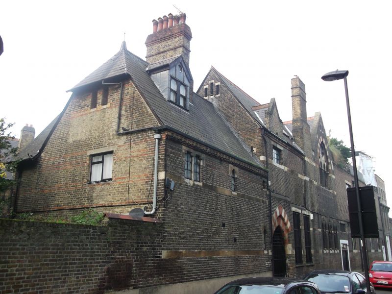
1860-1, by J L Pearson. Two storeys, of stock brick with bands and dressings of red brick and Bath stone.
Tiled roofs. Irregular composition in picturesque Gothic style, with steeply pitched roofs and tall chimneys.
Mullioned windows, some with pointed or cusped lights. South end consists of former master's house with
half-hipped gable end. Former school to north of entrance arch groups with house and east end of St Peter's
Church to form irregular court. Entrance to school on west side of court below a pyramidal tower. Some
later alterations to fenestration on ground floor, north side of court. North of the building, the former art
school at nos. 34-36 (1860-1) and soup kitchen (1863-4), also by Pearson, still remain but in altered form
and are not included in the listing. The foundation stone of the schools was laid by the Prince of Wales on
27 June 1860. " "
Source: Athony Quiney, John Loughborough Pearson, 1979, pp 64-7, 260.
------------------------------------
ST OSWALD'S PLACE SE11
1.
5023
St Peter's School
TQ 3078 4/494 27.1.81
II GV
2.
Circa 1864. By J L Pearson. Very irregular U-shaped two storey building of stock
brick with bands and dressings of red brick and stone. Very steeply pitched slated
roofs with fancy ridge tiles. Projecting chimney breasts breaking eaves with
tall shafts soaring up beyond roof ridge. Most windows grouped in twos and fours,
with stone heads and cusped, pointed or round lights, some with pierced trefoils.
Projecting square tower in angle has pyramidal roof with dormer.
Listing NGR: TQ3072678133
External links are from the relevant listing authority and, where applicable, Wikidata. Wikidata IDs may be related buildings as well as this specific building. If you want to add or update a link, you will need to do so by editing the Wikidata entry.


Other nearby listed buildings
