Approximate Location Map
Large Map »
Latitude: 51.4682 / 51°28'5"N
Longitude: -0.1445 / 0°8'40"W
OS Eastings: 528977
OS Northings: 175995
OS Grid: TQ289759
Mapcode National: GBR CW.QV
Mapcode Global: VHGR5.FCY9
Plus Code: 9C3XFV94+75
Entry Name: The Plough Brewery
Listing Date: 22 May 1974
Grade: II
Source: Historic England
Source ID: 1356191
English Heritage Legacy ID: 204768
ID on this website: 101356191
Location: Clapham, Lambeth, London, SW8
County: London
District: Lambeth
Electoral Ward/Division: Clapham Town
Parish: Non Civil Parish
Built-Up Area: Lambeth
Traditional County: Surrey
Lieutenancy Area (Ceremonial County): Greater London
Church of England Parish: Clapham St Paul
Church of England Diocese: Southwark
Tagged with: Pub
WANDSWORTH ROAD SW8
1. (west side)
5023
No 516
('The Plough Brewery') )
TQ 2876 10/1045
TQ 2875 15/1045 22.5.74
II GV
2.
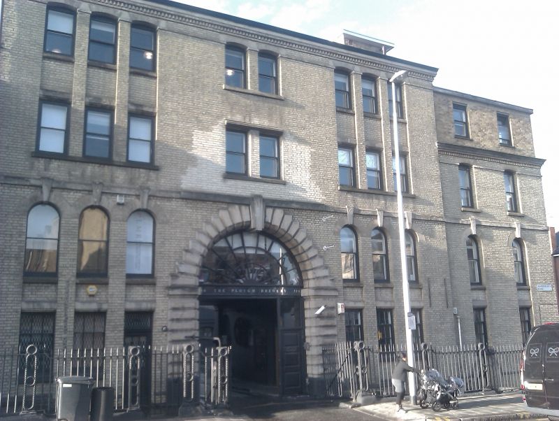
Former Plough Brewery. 1868, built on site of earlier brewery. Now in use as
offices and warehouses but former name reapplied over entrance. Main front of
4 storeys and basement, 3 wide bays with windows grouped 3, 2 and 3 on each floor.
Yellowish brick with stone dressings. Fairly low-pitched hipped slate roof.
Stone cornice above course of diagonal bricks. Sash windows set in deep narrow
recesses running through 2 floors, the upper ones segmental, the lower round-arched
with keystones overlapping second floor band. Some rebuilding at second floor
centre. Central carriage archway has rusticated stone jambs and voussoirs. Modern
doors and radial fanlight. Three-storey and basement right extension with added
modern fourth storey. Thick cast iron area railings, with twist sections, have
square piers with cable mouldings and monogram of brewer, Thomas Woodward, in
heads. Central double and side single gates of same pattern. Four-bay return
to Silverthorne Road, and beyond this a tall one storey wall with arcaded basement
windows; these belong to the undercroft beneath the inner courtyard, a large
groin-vaulted chamber of 5 by 6 aisles, the vaults supported on low, thick round
piers with Romanesque scalloped capitals. Inner courtyard walls remain as do
buildings to west, although the north (stable) building was destroyed by fire.
Within the west building, slender cast iron columns with lotus capitals support
upper floor. Wood framed roof has queen post trusses with raised centres and
bracing struts to principals and centre. In west side of front range a rectangular
stairwell has cantilevered staircase, with twist cast iron balusters and cast
iron handrail, running from ground floor down to sub-basement, which has segmental
and barrel-vaulted passages.
See also entry for outer courtyard walls under Peardon Street.
Listing NGR: TQ2897775995
External links are from the relevant listing authority and, where applicable, Wikidata. Wikidata IDs may be related buildings as well as this specific building. If you want to add or update a link, you will need to do so by editing the Wikidata entry.


Other nearby listed buildings
