Approximate Location Map
Large Map »
Latitude: 51.5834 / 51°35'0"N
Longitude: 0.0195 / 0°1'10"E
OS Eastings: 540018
OS Northings: 189106
OS Grid: TQ400891
Mapcode National: GBR LN.X5W
Mapcode Global: VHHN4.9G5H
Plus Code: 9F32H2M9+9R
Entry Name: White Lodge
Listing Date: 20 December 1954
Grade: II
Source: Historic England
Source ID: 1081011
English Heritage Legacy ID: 204873
ID on this website: 101081011
Location: Snaresbrook, Redbridge, London, E11
County: London
District: Redbridge
Electoral Ward/Division: Snaresbrook
Parish: Non Civil Parish
Built-Up Area: Redbridge
Traditional County: Essex
Lieutenancy Area (Ceremonial County): Greater London
Church of England Parish: Wanstead St Mary with Christ Church
Church of England Diocese: Chelmsford
Tagged with: Gatehouse
1.
5027
TQ 48 NW
4/2
20.12.54
SNARESBROOK ROAD E11
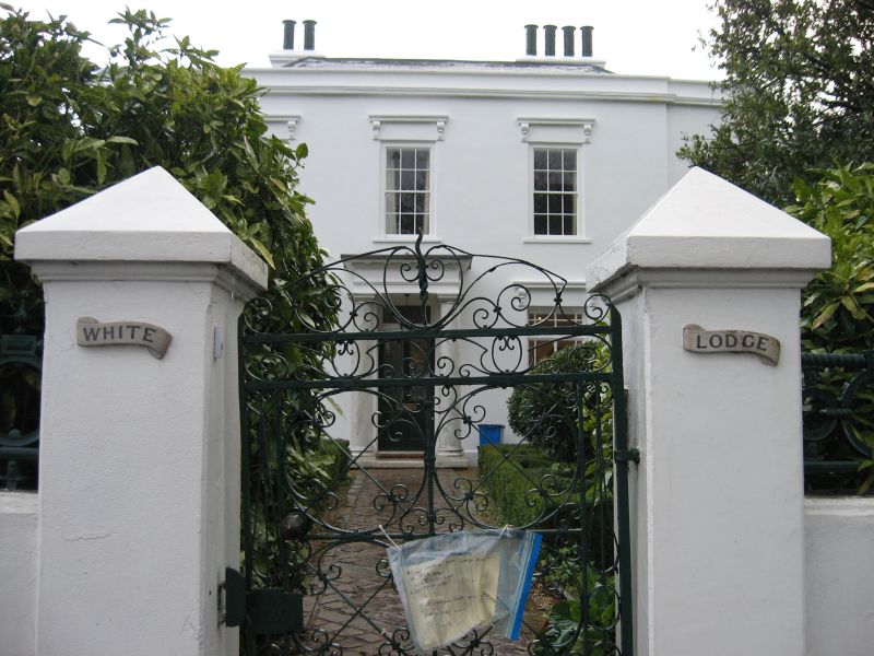
White Lodge
II
2.
Probably early C19. Two storeys, stucco, 3 sash windows with skied cornices
of consoles and modern painted jalousies. Central Doric columned porch, stucco
cornice and parapet. Slate roof. Bowed ends, with one sash window each.
Listing NGR: TQ4001889106
External links are from the relevant listing authority and, where applicable, Wikidata. Wikidata IDs may be related buildings as well as this specific building. If you want to add or update a link, you will need to do so by editing the Wikidata entry.


Other nearby listed buildings
