Approximate Location Map
Large Map »
Latitude: 51.4119 / 51°24'42"N
Longitude: -0.3107 / 0°18'38"W
OS Eastings: 517582
OS Northings: 169456
OS Grid: TQ175694
Mapcode National: GBR 78.Y2Q
Mapcode Global: VHGR8.KRMZ
Plus Code: 9C3XCM6Q+QP
Entry Name: 4, High Street
Listing Date: 25 June 1983
Grade: II
Source: Historic England
Source ID: 1065422
English Heritage Legacy ID: 205446
ID on this website: 101065422
Location: Hampton Wick, Richmond upon Thames, London, KT1
County: London
District: Richmond upon Thames
Electoral Ward/Division: Hampton Wick
Parish: Non Civil Parish
Built-Up Area: Richmond upon Thames
Traditional County: Middlesex
Lieutenancy Area (Ceremonial County): Greater London
Church of England Parish: St Mark, Teddington and St John the Baptist, Hampton Wick
Church of England Diocese: London
Tagged with: Building
1.
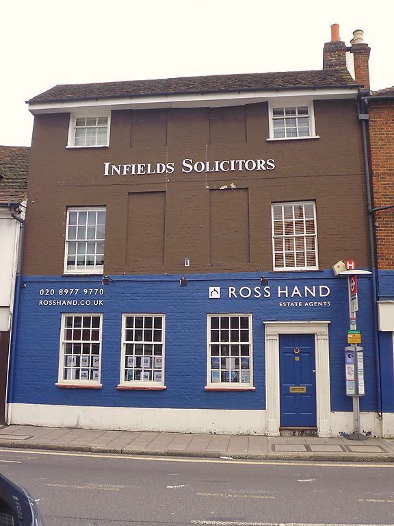
5028 HIGH STREET
(east side)
Hampton Wick
No 4
TQ 1769 31/20
II GV
2.
Early C18. Three storeys. Four windows wide. Tiled roof with deep eaves. Painted
brick facade with central pairs of windows blind. C19 shop front.
Listing NGR: TQ1758269456
External links are from the relevant listing authority and, where applicable, Wikidata. Wikidata IDs may be related buildings as well as this specific building. If you want to add or update a link, you will need to do so by editing the Wikidata entry.


Other nearby listed buildings
