Approximate Location Map
Large Map »
Latitude: 51.4124 / 51°24'44"N
Longitude: -0.3106 / 0°18'38"W
OS Eastings: 517588
OS Northings: 169504
OS Grid: TQ175695
Mapcode National: GBR 78.Y2L
Mapcode Global: VHGR8.KRPN
Plus Code: 9C3XCM6Q+WQ
Entry Name: 16, High Street
Listing Date: 16 April 1971
Grade: II
Source: Historic England
Source ID: 1065424
English Heritage Legacy ID: 205448
ID on this website: 101065424
Location: Hampton Wick, Richmond upon Thames, London, KT1
County: London
District: Richmond upon Thames
Electoral Ward/Division: Hampton Wick
Parish: Non Civil Parish
Built-Up Area: Richmond upon Thames
Traditional County: Middlesex
Lieutenancy Area (Ceremonial County): Greater London
Church of England Parish: St Mark, Teddington and St John the Baptist, Hampton Wick
Church of England Diocese: London
Tagged with: Building
1.
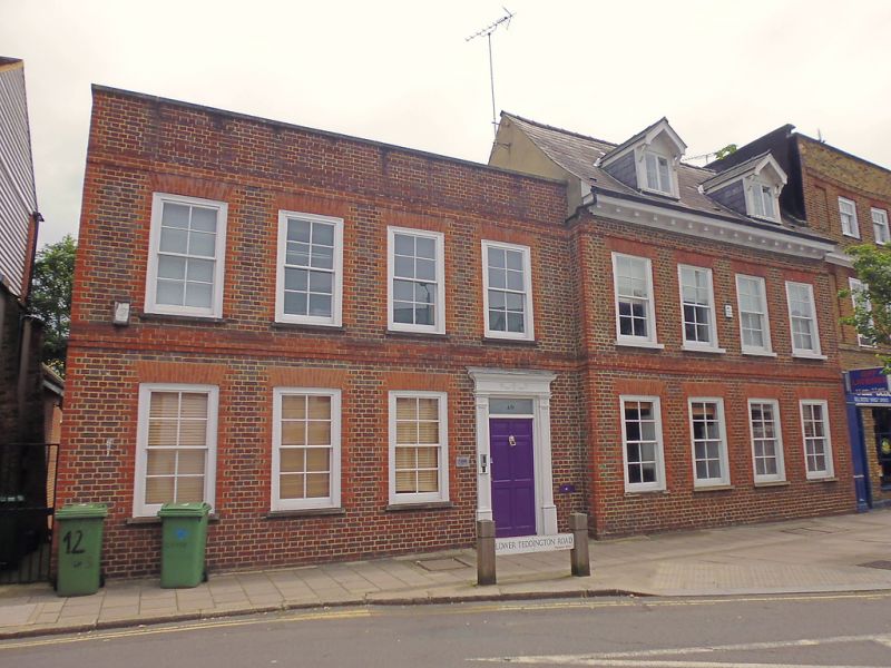
5028 HIGH STREET
(east side)
No 16
TQ 1769 31/14 16.4.71
II
2.
Early C18. Two storeys and attic. Four windows wide and 2 dormers. Slate roof with
dentilled eaves. Brick with ground floor rebuilt. (R.C.H.M. Middx. Vol.)
Listing NGR: TQ1600871097
External links are from the relevant listing authority and, where applicable, Wikidata. Wikidata IDs may be related buildings as well as this specific building. If you want to add or update a link, you will need to do so by editing the Wikidata entry.


Other nearby listed buildings
