Approximate Location Map
Large Map »
Latitude: 51.4692 / 51°28'9"N
Longitude: -0.2332 / 0°13'59"W
OS Eastings: 522814
OS Northings: 175950
OS Grid: TQ228759
Mapcode National: GBR 9P.5W8
Mapcode Global: VHGR3.XB2K
Plus Code: 9C3XFQ98+MP
Entry Name: Toll House
Listing Date: 25 June 1983
Grade: II
Source: Historic England
Source ID: 1357726
English Heritage Legacy ID: 205560
ID on this website: 101357726
Location: Richmond upon Thames, London, SW15
County: London
District: Richmond upon Thames
Electoral Ward/Division: Thamesfield
Parish: Non Civil Parish
Traditional County: Surrey
Lieutenancy Area (Ceremonial County): Greater London
Church of England Parish: Barnes St Mary
Church of England Diocese: Southwark
Tagged with: Tollhouse
1.
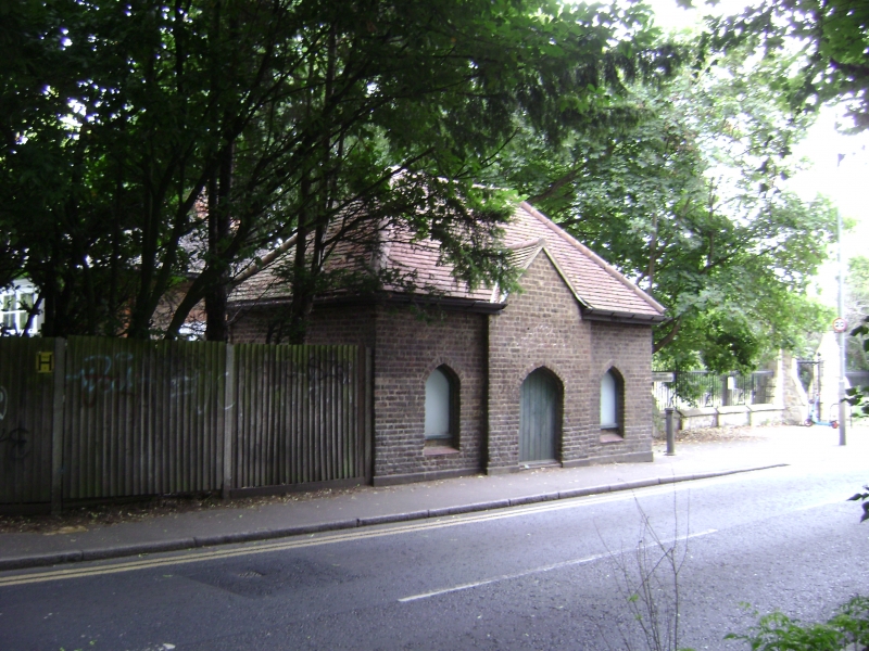
5028 MILL HILL ROAD
Toll House
TQ 27 NW 2/2
II
2.
Early C19 former toll house at boundary between Barnes Common and Putney Common.
One storey, 3 bays wide. Centre bay projects slightly. Brick with hipped tile
roof with gable over centre bay. Two-centred-arched openings to door and windows.
Listing NGR: TQ2281475950
External links are from the relevant listing authority and, where applicable, Wikidata. Wikidata IDs may be related buildings as well as this specific building. If you want to add or update a link, you will need to do so by editing the Wikidata entry.


Other nearby listed buildings
