Approximate Location Map
Large Map »
Latitude: 51.5034 / 51°30'12"N
Longitude: -0.0621 / 0°3'43"W
OS Eastings: 534601
OS Northings: 180050
OS Grid: TQ346800
Mapcode National: GBR ZH.68
Mapcode Global: VHGR0.WG1W
Plus Code: 9C3XGW3Q+85
Entry Name: Town of Ramsgate Public House
Listing Date: 27 September 1973
Grade: II
Source: Historic England
Source ID: 1065804
English Heritage Legacy ID: 206320
Also known as: The Town of Ramsgate
Town of Ramsgate, Wapping
ID on this website: 101065804
Location: Wapping, Tower Hamlets, London, E1W
County: London
District: Tower Hamlets
Electoral Ward/Division: St Katharine's & Wapping
Parish: Non Civil Parish
Built-Up Area: Tower Hamlets
Traditional County: Middlesex
Lieutenancy Area (Ceremonial County): Greater London
Church of England Parish: St Peter London Docks
Church of England Diocese: London
Tagged with: Pub
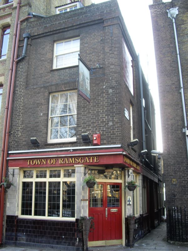
1. WAPPING HIGH STREET E1
4431
(south Side)
Town of Ramsgate
Public House
TQ 3480 22/787
II GV
2.
C18 on earlier foundation, later additions and extensive alterations to facade.
Brown brick with eaves cornice and blocking course, stone band between ground
and 1st floor. Roof not visible. 3 storeys and dormers. 1 window 2nd floor recessed
with brick side pilasters, sash window, vertical glazing bars only. 1st floor
window with glazing bars. Corner door and additional window facing west. Rear
canted 1st floor bay window. Inside, beamed ceilings, benches, plank panelling
and engraved glass screen.
Judge Jeffreys was reputedly captured at this inn. Included for interior, group
value and historical associations.
The iron railings and paved roadway of Wapping Pier Head form a group with
Nos 1 to 15 (consec) and No 4½, Town of Ramsgate Public House, Oliver's Wharf
and this section of the wall and entrance to London Docks, and 4 Bollards,
Wapping Old Stairs, Wapping High Street.
Listing NGR: TQ3460180050
External links are from the relevant listing authority and, where applicable, Wikidata. Wikidata IDs may be related buildings as well as this specific building. If you want to add or update a link, you will need to do so by editing the Wikidata entry.


Other nearby listed buildings
