Approximate Location Map
Large Map »
Latitude: 51.3653 / 51°21'55"N
Longitude: -0.1625 / 0°9'45"W
OS Eastings: 528014
OS Northings: 164519
OS Grid: TQ280645
Mapcode National: GBR DD.RPW
Mapcode Global: VHGRK.4YF7
Plus Code: 9C3X9R8P+4X
Entry Name: Gates adjoining No 1 at south-west entrance to The Grove
Listing Date: 1 March 1974
Grade: II
Source: Historic England
Source ID: 1065682
English Heritage Legacy ID: 206725
ID on this website: 101065682
Location: The Grove, Carshalton, Sutton, London, SM5
County: London
District: Sutton
Electoral Ward/Division: Carshalton Central
Parish: Non Civil Parish
Built-Up Area: Sutton
Traditional County: Surrey
Lieutenancy Area (Ceremonial County): Greater London
Church of England Parish: Carshalton All Saints
Church of England Diocese: Southwark
Tagged with: Gate
This list entry was subject to a Minor Amendment on 22/01/2020
TQ 2864 NW
21/71
CARSHALTON
HIGH STREET (north side)
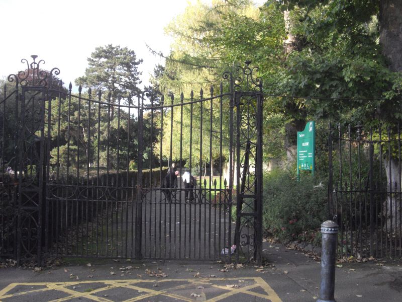
Gates adjoining No 1 at south-west entrance to The Grove
GV
II
Gates and railings in C18 style. Double wrought iron gates with single gate to right hand; gates flanked to either side by railings. Double gates with topmost rail set in an inverted curve. Uprights with spear-headed finials rise alternately to two different heights; curvilinear design in lock rail. Panelled standards with small overthrows flanking gates. To either side again, topmost rails of smaller gate and of railings with inverted curve.
Road bridge, Leoni Bridge, culvert and retaining walls to Carshalton Ponds form a group with No 1 High Street and entrance gates to the Grove, with Honeywood Museum and Wall and Gatehouse, Honeywood Walk, with Anne Boleyn's Well, St Mary's and Madeley Cottage, in Church Hill and with the following items on the south side of the High Street: Greyhound Inn, wall to east of Greyhound Inn, Church of All Saints, north churchyard wall and Nos 6 and 12 High Street.
Listing NGR: TQ2801464518
External links are from the relevant listing authority and, where applicable, Wikidata. Wikidata IDs may be related buildings as well as this specific building. If you want to add or update a link, you will need to do so by editing the Wikidata entry.


Other nearby listed buildings
