Approximate Location Map
Large Map »
Latitude: 51.365 / 51°21'54"N
Longitude: -0.1649 / 0°9'53"W
OS Eastings: 527853
OS Northings: 164485
OS Grid: TQ278644
Mapcode National: GBR DD.YYQ
Mapcode Global: VHGRK.3Y6F
Plus Code: 9C3X9R8P+23
Entry Name: South boundary wall to Honeywood Museum and gateways
Listing Date: 1 March 1974
Grade: II
Source: Historic England
Source ID: 1357616
English Heritage Legacy ID: 206737
ID on this website: 101357616
Location: Carshalton, Sutton, London, SM5
County: London
District: Sutton
Electoral Ward/Division: Carshalton Central
Parish: Non Civil Parish
Built-Up Area: Sutton
Traditional County: Surrey
Lieutenancy Area (Ceremonial County): Greater London
Church of England Parish: Carshalton All Saints
Church of England Diocese: Southwark
Tagged with: Wall
This list entry was subject to a Minor Amendment on 22/01/2020
TQ 2764 SE
20/132
CARSHALTON
HONEYWOOD WALK
South boundary wall to Honeywood Museum and gateways
(Formerly listed as South boundary wall to Honeywood Lodge and gateways)
GV
II
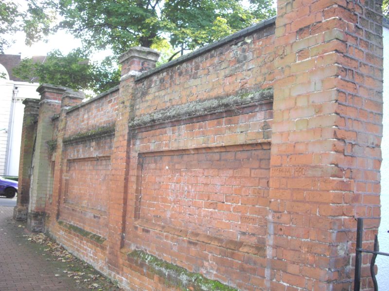
Western part of C18 to C19 date with later repatching. Red brick with dark blue brick coping; incorporates gateway. A late C19 red brick wall returns northward from south-east corner; this is divided into four bays by brick pilasters with capping; moulded course, recessed panel in lower part of wall. In second bay from south, a two-centred stone gateway with wooden door.
Honeywood Museum and wall form a group with The Gate House, with road bridge, Leoni bridge, culvert and retaining walls to Carshalton Ponds, with No 1 High Street and entrance gates to The Grove, High Street (north side), with Anne Boleyn's Well, St Mary's and Madeley Cottage in Church Hill and with the following items on the South side of the High Street: the Greyhound Inn, Wall to east of the Greyhound, Church of All Saints, north churchyard wall and No 6 High Street.
Listing NGR: TQ2785364485
External links are from the relevant listing authority and, where applicable, Wikidata. Wikidata IDs may be related buildings as well as this specific building. If you want to add or update a link, you will need to do so by editing the Wikidata entry.


Other nearby listed buildings
