Approximate Location Map
Large Map »
Latitude: 51.3642 / 51°21'51"N
Longitude: -0.1646 / 0°9'52"W
OS Eastings: 527871
OS Northings: 164396
OS Grid: TQ278643
Mapcode National: GBR DD.Z0B
Mapcode Global: VHGRK.3ZB1
Plus Code: 9C3X9R7P+M4
Entry Name: 5A, Orchard Hill
Listing Date: 1 March 1974
Grade: II
Source: Historic England
Source ID: 1065659
English Heritage Legacy ID: 206768
ID on this website: 101065659
Location: Carshalton, Sutton, London, SM5
County: London
District: Sutton
Electoral Ward/Division: Carshalton Central
Parish: Non Civil Parish
Built-Up Area: Sutton
Traditional County: Surrey
Lieutenancy Area (Ceremonial County): Greater London
Church of England Parish: Carshalton All Saints
Church of England Diocese: Southwark
Tagged with: Building
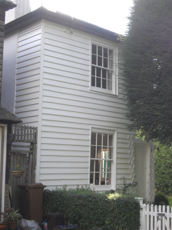
ORCHARD HILL
1.
4430
CARSHALTON
No 5A
TQ 2764 SE 20/131
II
2.
C19 probably. Front of 2 storeys, 1 window bay to Orchard Hill. Pyramidal slate
roof. Weatherboarded cladding. Sash windows 4 panes wide. Panelled door to
right hand.
Listing NGR: TQ2787164396
External links are from the relevant listing authority and, where applicable, Wikidata. Wikidata IDs may be related buildings as well as this specific building. If you want to add or update a link, you will need to do so by editing the Wikidata entry.


Other nearby listed buildings
