Approximate Location Map
Large Map »
Latitude: 51.365 / 51°21'53"N
Longitude: -0.1645 / 0°9'52"W
OS Eastings: 527878
OS Northings: 164477
OS Grid: TQ278644
Mapcode National: GBR DD.Z1C
Mapcode Global: VHGRK.3YDH
Plus Code: 9C3X9R7P+X6
Entry Name: The Greyhound Inn
Listing Date: 16 March 1954
Grade: II
Source: Historic England
Source ID: 1065623
English Heritage Legacy ID: 206783
ID on this website: 101065623
Location: Carshalton, Sutton, London, SM5
County: London
District: Sutton
Electoral Ward/Division: Carshalton Central
Parish: Non Civil Parish
Built-Up Area: Sutton
Traditional County: Surrey
Lieutenancy Area (Ceremonial County): Greater London
Church of England Parish: Carshalton All Saints
Church of England Diocese: Southwark
This list entry was subject to a Minor Amendment on 22/01/2020
TQ 2764 SE
20/75
CARSHALTON
POUND STREET (south side)
The Greyhound Inn
16.3.54.
GV
II
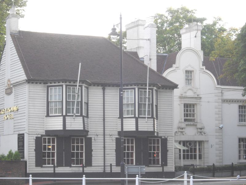
Right hand part apparently early C19, but probably a remodelling of an earlier building. Two storeys, stucco, three sash windows, the centre one on full height three-storey projection beneath Dutch gable. Quoins. Central Jacobean style feature enclosing doors and window with pilasters, cornices and strapwork ornament. Quoins to wings, modillion cornice, parapet, old tile roof. Dutch gable also to right hand return. Projecting portion to left is C18, painted weatherboarding, two storeys. Four sash windows to ground floor with old panelled shutters, first floor has two large overhanging canted sashed bays. Dentil eaves cornice continued round bays. Tile roof with hip to right. A list of voluntary rate payers for October 1707 refers to "John Watson at the sign of the Greyhound".
The Greyhound Inn, wall to east of the Greyhound, Church of All Saints, North Churchyard wall and Nos 6 and 12 (Coach and Horses) form a group with Anne Boleyn's Well, St Mary's and Madeley Cottage in Church Hill and with the following items: with No 1 High Street and entrance gates to The Grove, with road bridge, Leoni bridge, culvert and retaining walls to Carshalton Ponds and with Honeywood Museum and walls, Honeywood Walk and The Gate House.
Listing NGR: TQ2787864477
External links are from the relevant listing authority and, where applicable, Wikidata. Wikidata IDs may be related buildings as well as this specific building. If you want to add or update a link, you will need to do so by editing the Wikidata entry.


Other nearby listed buildings
