Approximate Location Map
Large Map »
Latitude: 51.5749 / 51°34'29"N
Longitude: -0.0152 / 0°0'54"W
OS Eastings: 537635
OS Northings: 188096
OS Grid: TQ376880
Mapcode National: GBR KV.DTK
Mapcode Global: VHGQN.PP90
Plus Code: 9C3XHXFM+XW
Entry Name: Bakers Almshouses
Listing Date: 27 September 1971
Grade: II
Source: Historic England
Source ID: 1191128
English Heritage Legacy ID: 206913
ID on this website: 101191128
Location: Leyton, Waltham Forest, London, E10
County: London
District: Waltham Forest
Electoral Ward/Division: Lea Bridge
Parish: Non Civil Parish
Built-Up Area: Waltham Forest
Traditional County: Essex
Lieutenancy Area (Ceremonial County): Greater London
Church of England Parish: Leyton All Saints
Church of England Diocese: Chelmsford
Tagged with: Almshouse
TQ 38 NE
2/22
27.9.71
LEA BRIDGE ROAD
Leyton, E10
(north side)
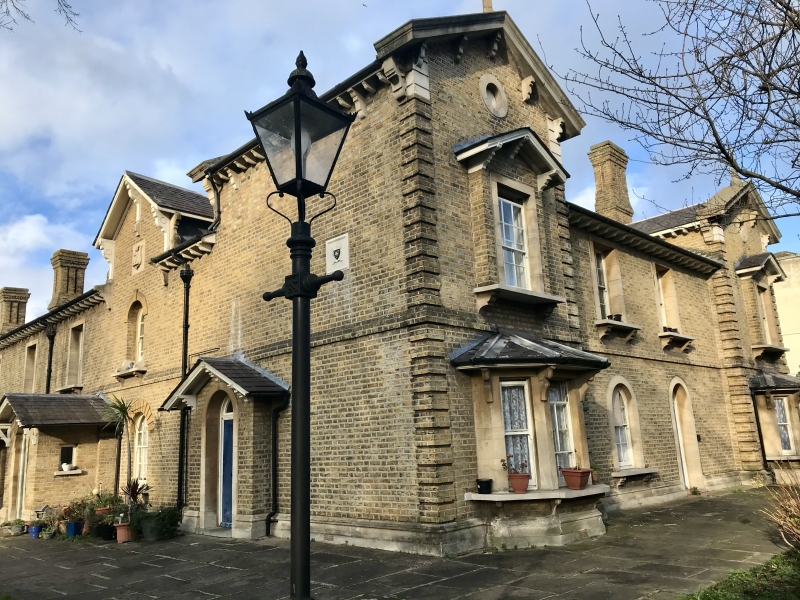
Bakers Almshouses
GV
II
Almshouses. 1857-66. By T E Knightley. Yellow brick, stone dressings, pitched
slate roof to eaves. Composed around 3 sides of open quadrangle. Eclectic
Italianate manner. Mainly 2 storeyed. Almshouses each 1 bay with gabled porch
shared with neighbour; decorative moulded entrances, panelled doors. Ground floor
windows, round-headed with rusticated gauged brick voussoirs. First floor windows
mainly square-headed, with stone architraves. Bracketed eaves. Tall panelled
chimneys, Italianate belvedere towers in each angle with low hipped roofs. Each wing
with central emphasis. Central block with centre 4 bays on larger scale with inset
clock, 2 corniced doorways, and gabled pavilions to either side with rusticated
quoins. Side wings with gabled centre and end pavilions more elaborate than intervening
units, those to centre with projecting balconied bay windows to first floor.
Side wings have symmetrical returns to road frontage, with paired gabled pavilions
and rusticated quoins. Rear elevation also of architectural interest.
Listing NGR: TQ3763588096
External links are from the relevant listing authority and, where applicable, Wikidata. Wikidata IDs may be related buildings as well as this specific building. If you want to add or update a link, you will need to do so by editing the Wikidata entry.


Other nearby listed buildings
