Approximate Location Map
Large Map »
Latitude: 51.455 / 51°27'17"N
Longitude: -0.1594 / 0°9'33"W
OS Eastings: 527982
OS Northings: 174495
OS Grid: TQ279744
Mapcode National: GBR F2.0HR
Mapcode Global: VHGR5.6P2G
Plus Code: 9C3XFR3R+X6
Entry Name: Walsingham School
Listing Date: 7 April 1983
Grade: II
Source: Historic England
Source ID: 1065557
English Heritage Legacy ID: 206998
ID on this website: 101065557
Location: Wandsworth Common, Wandsworth, London, SW11
County: London
District: Wandsworth
Electoral Ward/Division: Northcote
Parish: Non Civil Parish
Built-Up Area: Wandsworth
Traditional County: Surrey
Lieutenancy Area (Ceremonial County): Greater London
Church of England Parish: Battersea St Luke
Church of England Diocese: Southwark
Tagged with: Building
BROOMWOOD ROAD SW11
1.
5033
Walsingham School
TQ 27SE 4/11
TQ 2874 13/11
II
2.
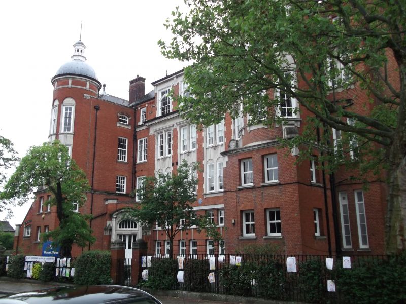
Designed 1907 as the LCC Clapham Secondary School for Girls under the supervision
of T J Bailey, Schools Architect. It is of 4-storeys in red brick with stone
dressings and tiled roof and is of complex symmetrical form on the entrance
elevation. This has a 6-bay centre enclosed by wings which are fronted with
2-storey blocks. The blocks rise into round towers having domes surmounted by open
octagonal domed lanterns with needle finials.
A canted porch fills the angle between the centre and each wing. It is framed by
piers with clasping buttresses and has an applied segmental doorcase on corbelled
columns.
A prominent cornice-band separates the second floor from a high attic with
elaborately glazed sashes and crowning cornice to the 4 centre bays.
The main roof is finished with a complex square lantern. Canted bows with
pyramidal roofs separate the entrance elevation from recessed 6-bay return
elevations which have round-headed ground floor windows within radially rusticated
heads.
Corbelled chimney breasts set laterally on the entrance elevation rise into tall
stacks.
Listing NGR: TQ2798274495
External links are from the relevant listing authority and, where applicable, Wikidata. Wikidata IDs may be related buildings as well as this specific building. If you want to add or update a link, you will need to do so by editing the Wikidata entry.


Other nearby listed buildings
